You are here: Home > Network List > TA - USArray Transportable Network (new EarthScope stations) Stations List
> Station H17A Grant Village (NPS), Yellowstone Nt. Park, WY, USA > Earthquake Result Viewer
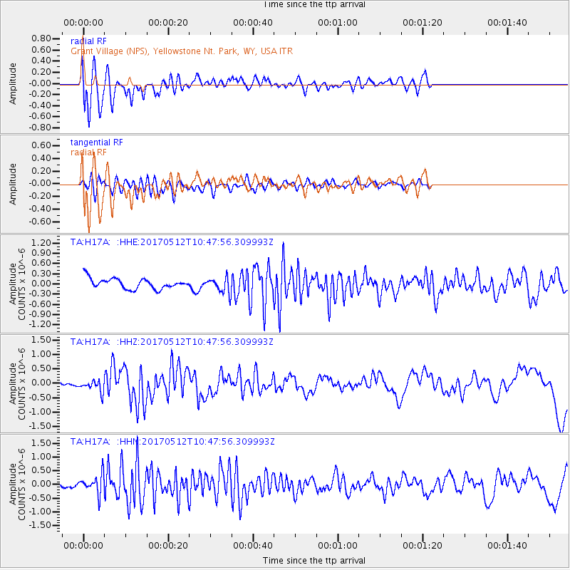
H17A Grant Village (NPS), Yellowstone Nt. Park, WY, USA - Earthquake Result Viewer
*The percent match for this event was below the threshold and hence no stack was calculated.
| Earthquake location: |
Off Coast Of Central America |
| Earthquake latitude/longitude: |
12.9/-90.1 |
| Earthquake time(UTC): |
2017/05/12 (132) 10:41:26 GMT |
| Earthquake Depth: |
10 km |
| Earthquake Magnitude: |
6.2 Mww |
| Earthquake Catalog/Contributor: |
NEIC PDE/us |
|
| Network: |
TA USArray Transportable Network (new EarthScope stations) |
| Station: |
H17A Grant Village (NPS), Yellowstone Nt. Park, WY, USA |
| Lat/Lon: |
44.40 N/110.58 W |
| Elevation: |
2400 m |
|
| Distance: |
36.0 deg |
| Az: |
334.664 deg |
| Baz: |
144.406 deg |
| Ray Param: |
$rayparam |
*The percent match for this event was below the threshold and hence was not used in the summary stack. |
|
| Radial Match: |
59.53784 % |
| Radial Bump: |
400 |
| Transverse Match: |
57.77846 % |
| Transverse Bump: |
400 |
| SOD ConfigId: |
11737051 |
| Insert Time: |
2019-04-27 08:57:59.334 +0000 |
| GWidth: |
2.5 |
| Max Bumps: |
400 |
| Tol: |
0.001 |
|
Signal To Noise
| Channel | StoN | STA | LTA |
| TA:H17A: :HHZ:20170512T10:47:56.309993Z | 1.913754 | 2.0419043E-7 | 1.0669628E-7 |
| TA:H17A: :HHN:20170512T10:47:56.309993Z | 4.679078 | 3.5304808E-7 | 7.545249E-8 |
| TA:H17A: :HHE:20170512T10:47:56.309993Z | 1.5122055 | 2.3057402E-7 | 1.5247531E-7 |
| Arrivals |
| Ps | |
| PpPs | |
| PsPs/PpSs | |


