You are here: Home > Network List > TA - USArray Transportable Network (new EarthScope stations) Stations List
> Station I23K Minto, Yukon-Koyukuk, AK, USA > Earthquake Result Viewer
I23K Minto, Yukon-Koyukuk, AK, USA - Earthquake Result Viewer
| Earthquake location: |
Off Coast Of Central America |
| Earthquake latitude/longitude: |
12.9/-90.1 |
| Earthquake time(UTC): |
2017/05/12 (132) 10:41:26 GMT |
| Earthquake Depth: |
10 km |
| Earthquake Magnitude: |
6.2 Mww |
| Earthquake Catalog/Contributor: |
NEIC PDE/us |
|
| Network: |
TA USArray Transportable Network (new EarthScope stations) |
| Station: |
I23K Minto, Yukon-Koyukuk, AK, USA |
| Lat/Lon: |
65.15 N/149.36 W |
| Elevation: |
149 m |
|
| Distance: |
65.7 deg |
| Az: |
336.501 deg |
| Baz: |
113.081 deg |
| Ray Param: |
0.05810172 |
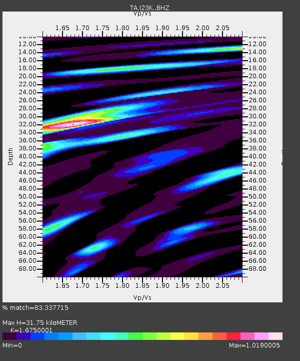
| Estimated Moho Depth: |
31.75 km |
| Estimated Crust Vp/Vs: |
1.68 |
| Assumed Crust Vp: |
6.566 km/s |
| Estimated Crust Vs: |
3.92 km/s |
| Estimated Crust Poisson's Ratio: |
0.22 |
|
| Radial Match: |
83.337715 % |
| Radial Bump: |
394 |
| Transverse Match: |
71.60988 % |
| Transverse Bump: |
400 |
| SOD ConfigId: |
11737051 |
| Insert Time: |
2019-04-27 08:58:04.464 +0000 |
| GWidth: |
2.5 |
| Max Bumps: |
400 |
| Tol: |
0.001 |
|
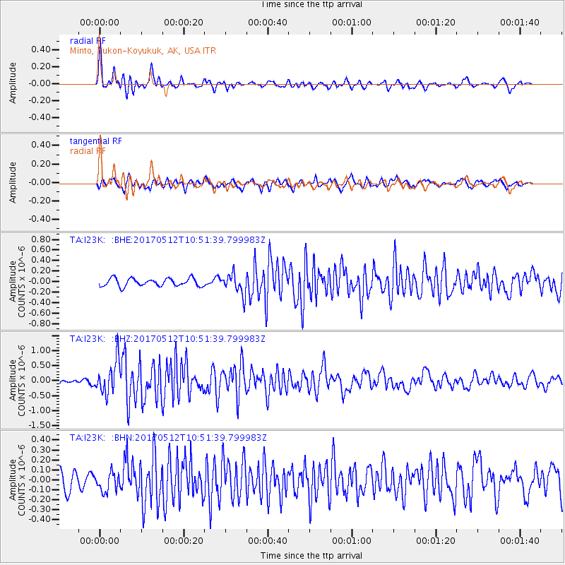
Signal To Noise
| Channel | StoN | STA | LTA |
| TA:I23K: :BHZ:20170512T10:51:39.799983Z | 10.384801 | 5.6107325E-7 | 5.4028312E-8 |
| TA:I23K: :BHN:20170512T10:51:39.799983Z | 1.1053529 | 9.5596356E-8 | 8.6484924E-8 |
| TA:I23K: :BHE:20170512T10:51:39.799983Z | 2.6323764 | 1.9713018E-7 | 7.488677E-8 |
| Arrivals |
| Ps | 3.4 SECOND |
| PpPs | 12 SECOND |
| PsPs/PpSs | 16 SECOND |


