You are here: Home > Network List > TA - USArray Transportable Network (new EarthScope stations) Stations List
> Station O30N Mendenhall, YT, Canada > Earthquake Result Viewer
O30N Mendenhall, YT, Canada - Earthquake Result Viewer
| Earthquake location: |
Off Coast Of Central America |
| Earthquake latitude/longitude: |
12.9/-90.1 |
| Earthquake time(UTC): |
2017/05/12 (132) 10:41:26 GMT |
| Earthquake Depth: |
10 km |
| Earthquake Magnitude: |
6.2 Mww |
| Earthquake Catalog/Contributor: |
NEIC PDE/us |
|
| Network: |
TA USArray Transportable Network (new EarthScope stations) |
| Station: |
O30N Mendenhall, YT, Canada |
| Lat/Lon: |
60.77 N/136.09 W |
| Elevation: |
821 m |
|
| Distance: |
58.3 deg |
| Az: |
335.464 deg |
| Baz: |
124.415 deg |
| Ray Param: |
0.062942766 |
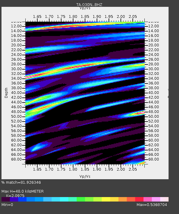
| Estimated Moho Depth: |
48.0 km |
| Estimated Crust Vp/Vs: |
2.10 |
| Assumed Crust Vp: |
6.566 km/s |
| Estimated Crust Vs: |
3.13 km/s |
| Estimated Crust Poisson's Ratio: |
0.35 |
|
| Radial Match: |
81.926346 % |
| Radial Bump: |
400 |
| Transverse Match: |
64.90173 % |
| Transverse Bump: |
400 |
| SOD ConfigId: |
11737051 |
| Insert Time: |
2019-04-27 08:58:40.542 +0000 |
| GWidth: |
2.5 |
| Max Bumps: |
400 |
| Tol: |
0.001 |
|

Signal To Noise
| Channel | StoN | STA | LTA |
| TA:O30N: :BHZ:20170512T10:50:50.099971Z | 2.8302088 | 2.9436572E-7 | 1.0400848E-7 |
| TA:O30N: :BHN:20170512T10:50:50.099971Z | 2.019739 | 1.0026306E-7 | 4.9641592E-8 |
| TA:O30N: :BHE:20170512T10:50:50.099971Z | 2.9502625 | 1.542854E-7 | 5.229548E-8 |
| Arrivals |
| Ps | 8.4 SECOND |
| PpPs | 22 SECOND |
| PsPs/PpSs | 30 SECOND |


