You are here: Home > Network List > TA - USArray Transportable Network (new EarthScope stations) Stations List
> Station Y30A Stafford Cattle Company, Roaring Springs, TX, USA > Earthquake Result Viewer
Y30A Stafford Cattle Company, Roaring Springs, TX, USA - Earthquake Result Viewer

| Earthquake location: |
Kodiak Island Region, Alaska |
| Earthquake latitude/longitude: |
56.5/-152.7 |
| Earthquake time(UTC): |
2009/03/30 (089) 07:13:07 GMT |
| Earthquake Depth: |
21 km |
| Earthquake Magnitude: |
5.9 MB, 5.9 MS, 5.9 MW, 5.9 MW |
| Earthquake Catalog/Contributor: |
WHDF/NEIC |
|
| Network: |
TA USArray Transportable Network (new EarthScope stations) |
| Station: |
Y30A Stafford Cattle Company, Roaring Springs, TX, USA |
| Lat/Lon: |
33.88 N/100.90 W |
| Elevation: |
812 m |
|
| Distance: |
41.7 deg |
| Az: |
100.45 deg |
| Baz: |
319.106 deg |
| Ray Param: |
0.073595345 |
| Estimated Moho Depth: |
15.75 km |
| Estimated Crust Vp/Vs: |
1.60 |
| Assumed Crust Vp: |
6.426 km/s |
| Estimated Crust Vs: |
4.01 km/s |
| Estimated Crust Poisson's Ratio: |
0.18 |
|
| Radial Match: |
85.04778 % |
| Radial Bump: |
400 |
| Transverse Match: |
71.75281 % |
| Transverse Bump: |
400 |
| SOD ConfigId: |
2658 |
| Insert Time: |
2010-03-05 23:51:34.650 +0000 |
| GWidth: |
2.5 |
| Max Bumps: |
400 |
| Tol: |
0.001 |
|
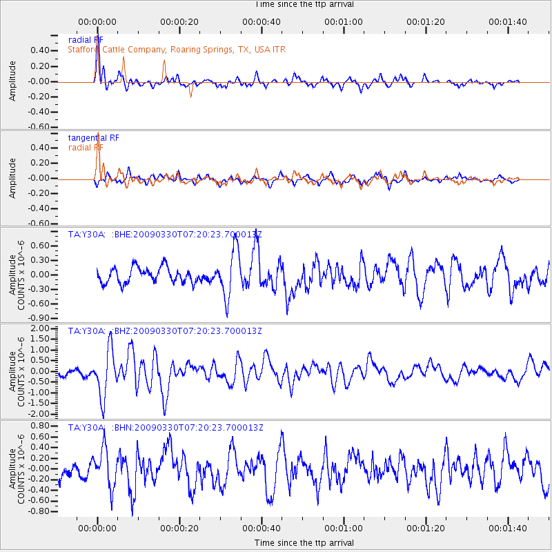
Signal To Noise
| Channel | StoN | STA | LTA |
| TA:Y30A: :BHZ:20090330T07:20:23.700013Z | 5.9398403 | 1.1351077E-6 | 1.9110072E-7 |
| TA:Y30A: :BHN:20090330T07:20:23.700013Z | 1.7899626 | 3.670036E-7 | 2.0503421E-7 |
| TA:Y30A: :BHE:20090330T07:20:23.700013Z | 3.1701164 | 5.032137E-7 | 1.5873665E-7 |
| Arrivals |
| Ps | 1.6 SECOND |
| PpPs | 5.9 SECOND |
| PsPs/PpSs | 7.5 SECOND |


