You are here: Home > Network List > AV - Alaska Volcano Observatory Stations List
> Station SPCR Ckakachatna River, Mount Spurr, Alaska > Earthquake Result Viewer
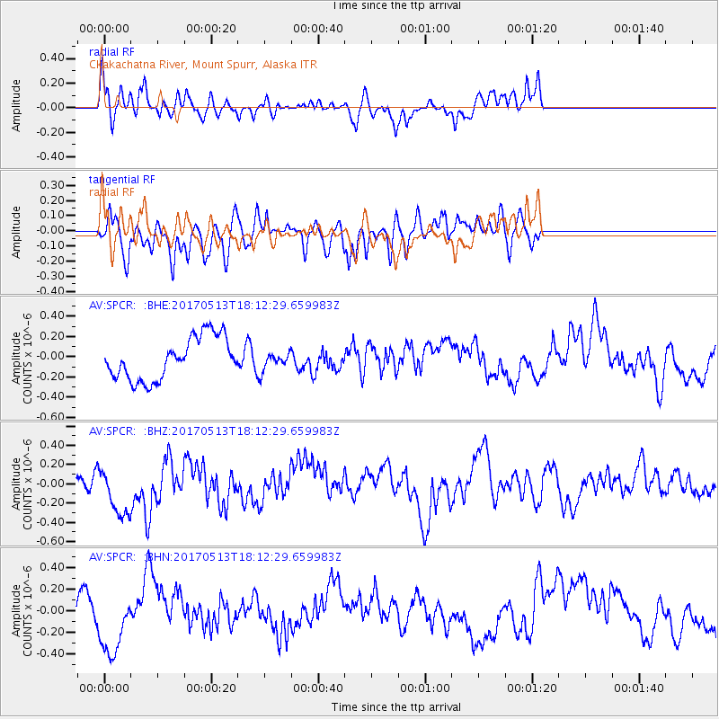
SPCR Ckakachatna River, Mount Spurr, Alaska - Earthquake Result Viewer
*The percent match for this event was below the threshold and hence no stack was calculated.
| Earthquake location: |
Turkmenistan-Iran Border Region |
| Earthquake latitude/longitude: |
37.9/57.3 |
| Earthquake time(UTC): |
2017/05/13 (133) 18:01:01 GMT |
| Earthquake Depth: |
12 km |
| Earthquake Magnitude: |
5.8 Mww |
| Earthquake Catalog/Contributor: |
NEIC PDE/us |
|
| Network: |
AV Alaska Volcano Observatory |
| Station: |
SPCR Ckakachatna River, Mount Spurr, Alaska |
| Lat/Lon: |
61.20 N/152.21 W |
| Elevation: |
984 m |
|
| Distance: |
78.4 deg |
| Az: |
14.078 deg |
| Baz: |
336.57 deg |
| Ray Param: |
$rayparam |
*The percent match for this event was below the threshold and hence was not used in the summary stack. |
|
| Radial Match: |
36.00284 % |
| Radial Bump: |
316 |
| Transverse Match: |
49.586197 % |
| Transverse Bump: |
400 |
| SOD ConfigId: |
11737051 |
| Insert Time: |
2019-04-27 09:03:40.324 +0000 |
| GWidth: |
2.5 |
| Max Bumps: |
400 |
| Tol: |
0.001 |
|
Signal To Noise
| Channel | StoN | STA | LTA |
| AV:SPCR: :BHZ:20170513T18:12:29.659983Z | 2.4410584 | 2.7503893E-7 | 1.12672E-7 |
| AV:SPCR: :BHN:20170513T18:12:29.659983Z | 1.4789994 | 3.397952E-7 | 2.297467E-7 |
| AV:SPCR: :BHE:20170513T18:12:29.659983Z | 0.2869365 | 5.9444528E-8 | 2.0716963E-7 |
| Arrivals |
| Ps | |
| PpPs | |
| PsPs/PpSs | |


