You are here: Home > Network List > TA - USArray Transportable Network (new EarthScope stations) Stations List
> Station V35K Ketchikan, AK, USA > Earthquake Result Viewer
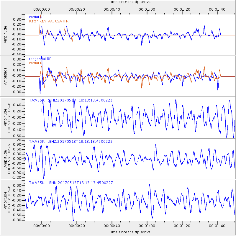
V35K Ketchikan, AK, USA - Earthquake Result Viewer
*The percent match for this event was below the threshold and hence no stack was calculated.
| Earthquake location: |
Turkmenistan-Iran Border Region |
| Earthquake latitude/longitude: |
37.9/57.3 |
| Earthquake time(UTC): |
2017/05/13 (133) 18:01:01 GMT |
| Earthquake Depth: |
12 km |
| Earthquake Magnitude: |
5.8 Mww |
| Earthquake Catalog/Contributor: |
NEIC PDE/us |
|
| Network: |
TA USArray Transportable Network (new EarthScope stations) |
| Station: |
V35K Ketchikan, AK, USA |
| Lat/Lon: |
55.33 N/131.62 W |
| Elevation: |
64 m |
|
| Distance: |
86.9 deg |
| Az: |
5.07 deg |
| Baz: |
352.969 deg |
| Ray Param: |
$rayparam |
*The percent match for this event was below the threshold and hence was not used in the summary stack. |
|
| Radial Match: |
56.142723 % |
| Radial Bump: |
375 |
| Transverse Match: |
66.41135 % |
| Transverse Bump: |
400 |
| SOD ConfigId: |
11737051 |
| Insert Time: |
2019-04-27 09:08:09.980 +0000 |
| GWidth: |
2.5 |
| Max Bumps: |
400 |
| Tol: |
0.001 |
|
Signal To Noise
| Channel | StoN | STA | LTA |
| TA:V35K: :BHZ:20170513T18:13:13.450022Z | 2.28757 | 6.9912045E-7 | 3.0561708E-7 |
| TA:V35K: :BHN:20170513T18:13:13.450022Z | 0.4032018 | 1.276325E-7 | 3.1654747E-7 |
| TA:V35K: :BHE:20170513T18:13:13.450022Z | 0.546181 | 1.6026189E-7 | 2.9342266E-7 |
| Arrivals |
| Ps | |
| PpPs | |
| PsPs/PpSs | |


