You are here: Home > Network List > GM - US Geological Survey Networks Stations List
> Station IWM01 Jericho 2M Well Monitoring Station > Earthquake Result Viewer
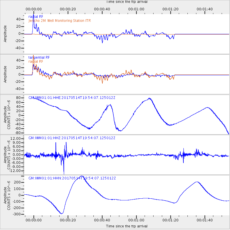
IWM01 Jericho 2M Well Monitoring Station - Earthquake Result Viewer
*The percent match for this event was below the threshold and hence no stack was calculated.
| Earthquake location: |
Chile-Bolivia Border Region |
| Earthquake latitude/longitude: |
-20.9/-68.7 |
| Earthquake time(UTC): |
2017/05/14 (134) 19:44:23 GMT |
| Earthquake Depth: |
124 km |
| Earthquake Magnitude: |
5.6 Mww |
| Earthquake Catalog/Contributor: |
NEIC PDE/us |
|
| Network: |
GM US Geological Survey Networks |
| Station: |
IWM01 Jericho 2M Well Monitoring Station |
| Lat/Lon: |
36.73 N/96.53 W |
| Elevation: |
328 m |
|
| Distance: |
63.1 deg |
| Az: |
335.15 deg |
| Baz: |
150.726 deg |
| Ray Param: |
$rayparam |
*The percent match for this event was below the threshold and hence was not used in the summary stack. |
|
| Radial Match: |
57.705 % |
| Radial Bump: |
304 |
| Transverse Match: |
75.53516 % |
| Transverse Bump: |
257 |
| SOD ConfigId: |
11737051 |
| Insert Time: |
2019-04-27 09:12:38.937 +0000 |
| GWidth: |
2.5 |
| Max Bumps: |
400 |
| Tol: |
0.001 |
|
Signal To Noise
| Channel | StoN | STA | LTA |
| GM:IWM01:01:HHZ:20170514T19:54:07.125012Z | 1.6755896 | 1.22221E-6 | 7.294209E-7 |
| GM:IWM01:01:HHN:20170514T19:54:07.125012Z | 0.29996136 | 1.5900747E-5 | 5.300932E-5 |
| GM:IWM01:01:HHE:20170514T19:54:07.125012Z | 3.4150286 | 9.184539E-5 | 2.6894471E-5 |
| Arrivals |
| Ps | |
| PpPs | |
| PsPs/PpSs | |


