You are here: Home > Network List > TA - USArray Transportable Network (new EarthScope stations) Stations List
> Station 130A Snyder, TX, USA > Earthquake Result Viewer
130A Snyder, TX, USA - Earthquake Result Viewer
| Earthquake location: |
Near Coast Of Venezuela |
| Earthquake latitude/longitude: |
10.7/-67.9 |
| Earthquake time(UTC): |
2009/09/12 (255) 20:06:24 GMT |
| Earthquake Depth: |
10 km |
| Earthquake Magnitude: |
6.3 MB, 6.4 MS, 6.3 MW, 6.3 MW |
| Earthquake Catalog/Contributor: |
WHDF/NEIC |
|
| Network: |
TA USArray Transportable Network (new EarthScope stations) |
| Station: |
130A Snyder, TX, USA |
| Lat/Lon: |
32.60 N/100.97 W |
| Elevation: |
676 m |
|
| Distance: |
37.4 deg |
| Az: |
310.731 deg |
| Baz: |
118.079 deg |
| Ray Param: |
0.0761544 |
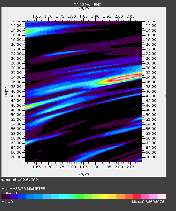
| Estimated Moho Depth: |
33.75 km |
| Estimated Crust Vp/Vs: |
2.03 |
| Assumed Crust Vp: |
6.426 km/s |
| Estimated Crust Vs: |
3.166 km/s |
| Estimated Crust Poisson's Ratio: |
0.34 |
|
| Radial Match: |
92.64382 % |
| Radial Bump: |
347 |
| Transverse Match: |
84.15122 % |
| Transverse Bump: |
386 |
| SOD ConfigId: |
2622 |
| Insert Time: |
2010-03-05 23:52:29.666 +0000 |
| GWidth: |
2.5 |
| Max Bumps: |
400 |
| Tol: |
0.001 |
|
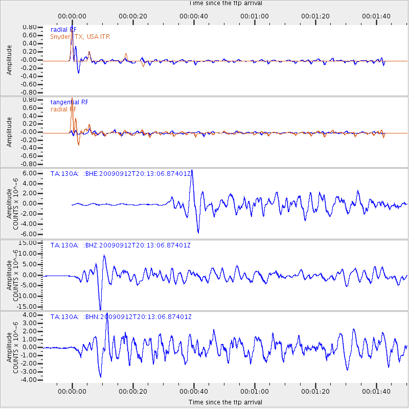
Signal To Noise
| Channel | StoN | STA | LTA |
| TA:130A: :BHZ:20090912T20:13:06.87401Z | 12.382313 | 1.30766E-6 | 1.05607086E-7 |
| TA:130A: :BHN:20090912T20:13:06.87401Z | 3.7619917 | 3.6563532E-7 | 9.719194E-8 |
| TA:130A: :BHE:20090912T20:13:06.87401Z | 5.691196 | 5.8310525E-7 | 1.0245743E-7 |
| Arrivals |
| Ps | 5.8 SECOND |
| PpPs | 15 SECOND |
| PsPs/PpSs | 21 SECOND |


