You are here: Home > Network List > TA - USArray Transportable Network (new EarthScope stations) Stations List
> Station 130A Snyder, TX, USA > Earthquake Result Viewer
130A Snyder, TX, USA - Earthquake Result Viewer
| Earthquake location: |
Tonga Islands |
| Earthquake latitude/longitude: |
-16.1/-173.3 |
| Earthquake time(UTC): |
2009/09/29 (272) 18:22:13 GMT |
| Earthquake Depth: |
10 km |
| Earthquake Magnitude: |
5.7 MB |
| Earthquake Catalog/Contributor: |
WHDF/NEIC |
|
| Network: |
TA USArray Transportable Network (new EarthScope stations) |
| Station: |
130A Snyder, TX, USA |
| Lat/Lon: |
32.60 N/100.97 W |
| Elevation: |
676 m |
|
| Distance: |
84.3 deg |
| Az: |
53.911 deg |
| Baz: |
246.946 deg |
| Ray Param: |
0.045557424 |
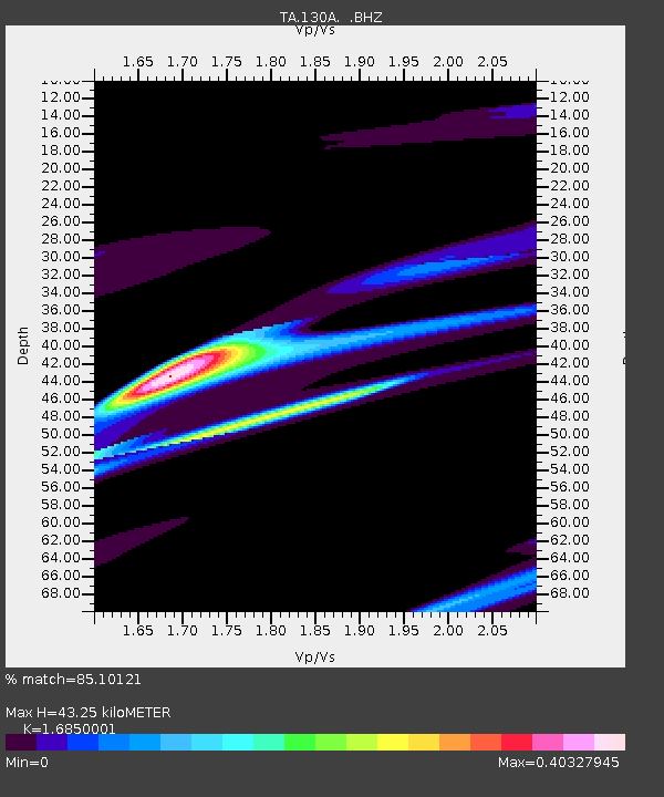
| Estimated Moho Depth: |
43.25 km |
| Estimated Crust Vp/Vs: |
1.69 |
| Assumed Crust Vp: |
6.426 km/s |
| Estimated Crust Vs: |
3.814 km/s |
| Estimated Crust Poisson's Ratio: |
0.23 |
|
| Radial Match: |
85.10121 % |
| Radial Bump: |
400 |
| Transverse Match: |
45.79366 % |
| Transverse Bump: |
219 |
| SOD ConfigId: |
2622 |
| Insert Time: |
2010-03-05 23:52:30.507 +0000 |
| GWidth: |
2.5 |
| Max Bumps: |
400 |
| Tol: |
0.001 |
|
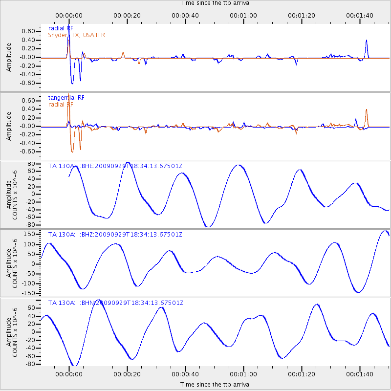
Signal To Noise
| Channel | StoN | STA | LTA |
| TA:130A: :BHZ:20090929T18:34:13.67501Z | 1.2855965 | 7.9484395E-5 | 6.182685E-5 |
| TA:130A: :BHN:20090929T18:34:13.67501Z | 4.521229 | 7.459248E-5 | 1.6498276E-5 |
| TA:130A: :BHE:20090929T18:34:13.67501Z | 0.9305046 | 4.8823076E-5 | 5.246946E-5 |
| Arrivals |
| Ps | 4.7 SECOND |
| PpPs | 18 SECOND |
| PsPs/PpSs | 22 SECOND |


