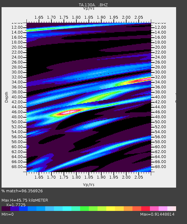
130A Snyder, TX, USA - Earthquake Result Viewer
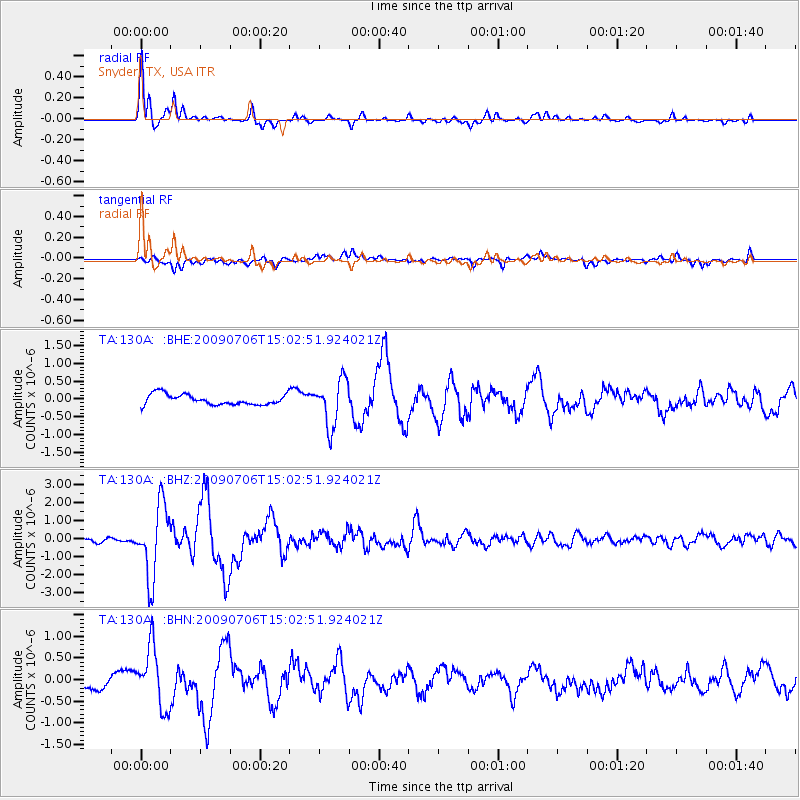
Earthquake location: Rat Islands, Aleutian Islands
Earthquake latitude/longitude: 50.4/177.0
Earthquake time(UTC): 2009/07/06 (187) 14:53:12 GMT
Earthquake Depth: 22 km
Earthquake Magnitude: 6.0 MB, 5.8 MS, 6.1 MW, 6.0 MW
Earthquake Catalog/Contributor: WHDF/NEIC
Network: TA USArray Transportable Network (new EarthScope stations)
Station: 130A Snyder, TX, USA
Lat/Lon: 32.60 N/100.97 W
Elevation: 676 m
Distance: 60.9 deg
Az: 73.161 deg
Baz: 313.523 deg
Ray Param: 0.061224222
Estimated Moho Depth: 45.75 km
Estimated Crust Vp/Vs: 1.77
Assumed Crust Vp: 6.426 km/s
Estimated Crust Vs: 3.625 km/s
Estimated Crust Poisson's Ratio: 0.27
Radial Match: 96.356926 %
Radial Bump: 315
Transverse Match: 74.51659 %
Transverse Bump: 400
SOD ConfigId: 2648
Insert Time: 2010-03-05 23:52:55.454 +0000
GWidth: 2.5
Max Bumps: 400
Tol: 0.001

Signal To Noise

ChannelStoNSTALTA
TA:130A: :BHZ:20090706T15:02:51.924021Z17.253692.002079E-61.1603773E-7
TA:130A: :BHN:20090706T15:02:51.924021Z5.3495836.9366075E-71.2966632E-7
TA:130A: :BHE:20090706T15:02:51.924021Z4.47568946.554653E-71.4645013E-7
Arrivals
Ps5.8 SECOND
PpPs19 SECOND
PsPs/PpSs25 SECOND