You are here: Home > Network List > G - GEOSCOPE Stations List
> Station CAN Canberra, Australia > Earthquake Result Viewer
CAN Canberra, Australia - Earthquake Result Viewer
| Earthquake location: |
Southeast Indian Ridge |
| Earthquake latitude/longitude: |
-47.7/85.2 |
| Earthquake time(UTC): |
2015/12/04 (338) 22:24:54 GMT |
| Earthquake Depth: |
10 km |
| Earthquake Magnitude: |
7.1 MWP |
| Earthquake Catalog/Contributor: |
NEIC PDE/NEIC COMCAT |
|
| Network: |
G GEOSCOPE |
| Station: |
CAN Canberra, Australia |
| Lat/Lon: |
35.32 S/149.00 E |
| Elevation: |
650 m |
|
| Distance: |
48.1 deg |
| Az: |
99.458 deg |
| Baz: |
234.506 deg |
| Ray Param: |
0.0695933 |
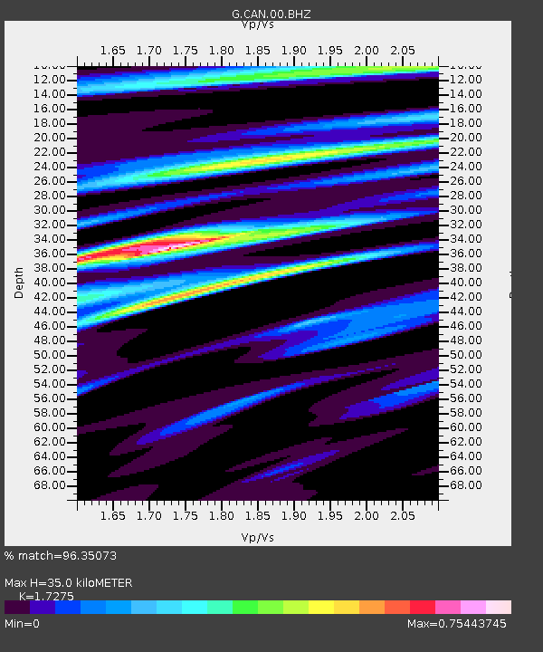
| Estimated Moho Depth: |
35.0 km |
| Estimated Crust Vp/Vs: |
1.73 |
| Assumed Crust Vp: |
6.633 km/s |
| Estimated Crust Vs: |
3.84 km/s |
| Estimated Crust Poisson's Ratio: |
0.25 |
|
| Radial Match: |
96.35073 % |
| Radial Bump: |
400 |
| Transverse Match: |
87.04866 % |
| Transverse Bump: |
400 |
| SOD ConfigId: |
1259291 |
| Insert Time: |
2015-12-18 23:13:44.737 +0000 |
| GWidth: |
2.5 |
| Max Bumps: |
400 |
| Tol: |
0.001 |
|
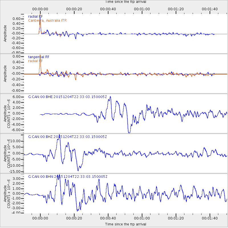
Signal To Noise
| Channel | StoN | STA | LTA |
| G:CAN:00:BHZ:20151204T22:33:03.150005Z | 7.2610435 | 2.4225315E-6 | 3.3363406E-7 |
| G:CAN:00:BHN:20151204T22:33:03.150005Z | 5.0596986 | 6.98143E-7 | 1.3798113E-7 |
| G:CAN:00:BHE:20151204T22:33:03.150005Z | 7.180443 | 1.1686113E-6 | 1.627492E-7 |
| Arrivals |
| Ps | 4.1 SECOND |
| PpPs | 13 SECOND |
| PsPs/PpSs | 18 SECOND |


