You are here: Home > Network List > TA - USArray Transportable Network (new EarthScope stations) Stations List
> Station 130A Snyder, TX, USA > Earthquake Result Viewer
130A Snyder, TX, USA - Earthquake Result Viewer
*The percent match for this event was below the threshold and hence no stack was calculated.
| Earthquake location: |
Catamarca Province, Argentina |
| Earthquake latitude/longitude: |
-27.9/-66.7 |
| Earthquake time(UTC): |
2009/08/12 (224) 18:00:52 GMT |
| Earthquake Depth: |
174 km |
| Earthquake Magnitude: |
5.5 MW, 5.3 MB, 5.5 MW |
| Earthquake Catalog/Contributor: |
WHDF/NEIC |
|
| Network: |
TA USArray Transportable Network (new EarthScope stations) |
| Station: |
130A Snyder, TX, USA |
| Lat/Lon: |
32.60 N/100.97 W |
| Elevation: |
676 m |
|
| Distance: |
68.4 deg |
| Az: |
329.24 deg |
| Baz: |
147.569 deg |
| Ray Param: |
$rayparam |
*The percent match for this event was below the threshold and hence was not used in the summary stack. |
|
| Radial Match: |
59.896687 % |
| Radial Bump: |
400 |
| Transverse Match: |
55.689526 % |
| Transverse Bump: |
400 |
| SOD ConfigId: |
2622 |
| Insert Time: |
2010-03-05 23:53:09.211 +0000 |
| GWidth: |
2.5 |
| Max Bumps: |
400 |
| Tol: |
0.001 |
|
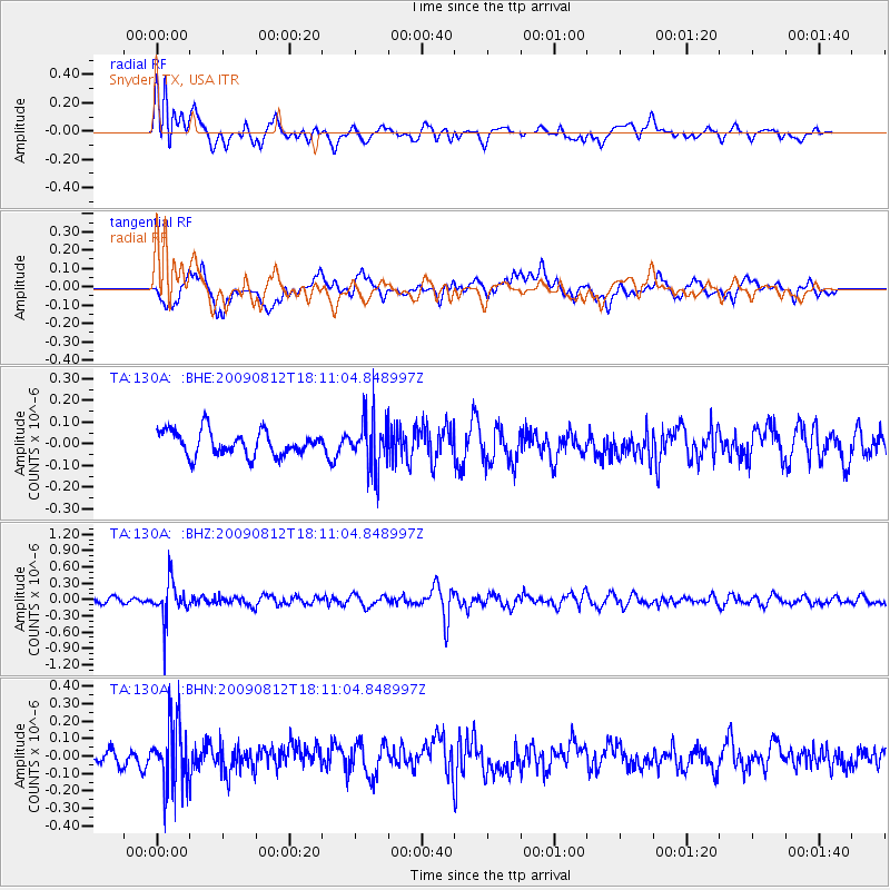
Signal To Noise
| Channel | StoN | STA | LTA |
| TA:130A: :BHZ:20090812T18:11:04.848997Z | 3.8690448 | 3.5268985E-7 | 9.115683E-8 |
| TA:130A: :BHN:20090812T18:11:04.848997Z | 4.599315 | 1.8268709E-7 | 3.9720497E-8 |
| TA:130A: :BHE:20090812T18:11:04.848997Z | 2.071787 | 1.16294004E-7 | 5.6132215E-8 |
| Arrivals |
| Ps | |
| PpPs | |
| PsPs/PpSs | |


