You are here: Home > Network List > TA - USArray Transportable Network (new EarthScope stations) Stations List
> Station 130A Snyder, TX, USA > Earthquake Result Viewer
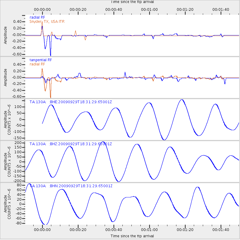
130A Snyder, TX, USA - Earthquake Result Viewer
*The percent match for this event was below the threshold and hence no stack was calculated.
| Earthquake location: |
Samoa Islands Region |
| Earthquake latitude/longitude: |
-15.9/-171.7 |
| Earthquake time(UTC): |
2009/09/29 (272) 18:19:35 GMT |
| Earthquake Depth: |
10 km |
| Earthquake Magnitude: |
5.6 MB |
| Earthquake Catalog/Contributor: |
WHDF/NEIC |
|
| Network: |
TA USArray Transportable Network (new EarthScope stations) |
| Station: |
130A Snyder, TX, USA |
| Lat/Lon: |
32.60 N/100.97 W |
| Elevation: |
676 m |
|
| Distance: |
83.0 deg |
| Az: |
53.386 deg |
| Baz: |
246.176 deg |
| Ray Param: |
$rayparam |
*The percent match for this event was below the threshold and hence was not used in the summary stack. |
|
| Radial Match: |
97.52865 % |
| Radial Bump: |
339 |
| Transverse Match: |
71.78414 % |
| Transverse Bump: |
400 |
| SOD ConfigId: |
2622 |
| Insert Time: |
2010-03-05 23:53:13.083 +0000 |
| GWidth: |
2.5 |
| Max Bumps: |
400 |
| Tol: |
0.001 |
|
Signal To Noise
| Channel | StoN | STA | LTA |
| TA:130A: :BHZ:20090929T18:31:29.65001Z | 0.93748546 | 8.992951E-5 | 9.5926305E-5 |
| TA:130A: :BHN:20090929T18:31:29.65001Z | 2.122466 | 8.669552E-5 | 4.08466E-5 |
| TA:130A: :BHE:20090929T18:31:29.65001Z | 1.1376957 | 7.779339E-5 | 6.837803E-5 |
| Arrivals |
| Ps | |
| PpPs | |
| PsPs/PpSs | |


