You are here: Home > Network List > TA - USArray Transportable Network (new EarthScope stations) Stations List
> Station R31K City Hall, Gustavus, AK, USA > Earthquake Result Viewer
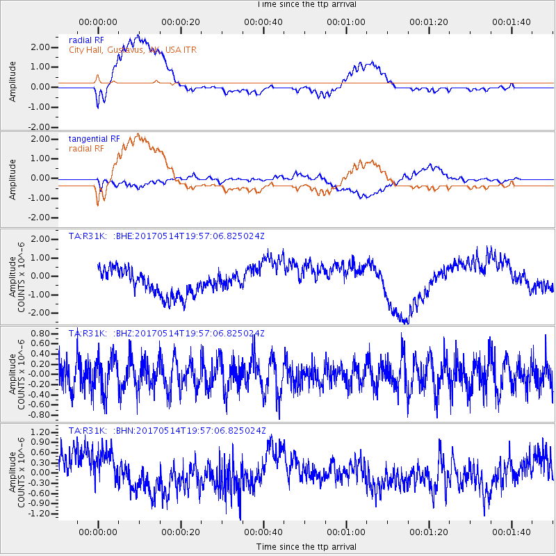
R31K City Hall, Gustavus, AK, USA - Earthquake Result Viewer
*The percent match for this event was below the threshold and hence no stack was calculated.
| Earthquake location: |
Chile-Bolivia Border Region |
| Earthquake latitude/longitude: |
-20.9/-68.7 |
| Earthquake time(UTC): |
2017/05/14 (134) 19:44:23 GMT |
| Earthquake Depth: |
124 km |
| Earthquake Magnitude: |
5.6 Mww |
| Earthquake Catalog/Contributor: |
NEIC PDE/us |
|
| Network: |
TA USArray Transportable Network (new EarthScope stations) |
| Station: |
R31K City Hall, Gustavus, AK, USA |
| Lat/Lon: |
58.41 N/135.74 W |
| Elevation: |
15 m |
|
| Distance: |
96.3 deg |
| Az: |
330.826 deg |
| Baz: |
120.029 deg |
| Ray Param: |
$rayparam |
*The percent match for this event was below the threshold and hence was not used in the summary stack. |
|
| Radial Match: |
49.082745 % |
| Radial Bump: |
400 |
| Transverse Match: |
48.132545 % |
| Transverse Bump: |
400 |
| SOD ConfigId: |
13570011 |
| Insert Time: |
2019-04-28 01:04:33.394 +0000 |
| GWidth: |
2.5 |
| Max Bumps: |
400 |
| Tol: |
0.001 |
|
Signal To Noise
| Channel | StoN | STA | LTA |
| TA:R31K: :BHZ:20170514T19:57:06.825024Z | 1.327351 | 3.6090987E-7 | 2.7190237E-7 |
| TA:R31K: :BHN:20170514T19:57:06.825024Z | 1.2056751 | 6.0501736E-7 | 5.0180796E-7 |
| TA:R31K: :BHE:20170514T19:57:06.825024Z | 0.5128552 | 3.541413E-7 | 6.9052885E-7 |
| Arrivals |
| Ps | |
| PpPs | |
| PsPs/PpSs | |


