You are here: Home > Network List > TA - USArray Transportable Network (new EarthScope stations) Stations List
> Station 130A Snyder, TX, USA > Earthquake Result Viewer
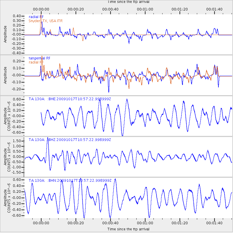
130A Snyder, TX, USA - Earthquake Result Viewer
*The percent match for this event was below the threshold and hence no stack was calculated.
| Earthquake location: |
Samoa Islands Region |
| Earthquake latitude/longitude: |
-16.4/-172.0 |
| Earthquake time(UTC): |
2009/10/17 (290) 10:45:26 GMT |
| Earthquake Depth: |
10 km |
| Earthquake Magnitude: |
5.7 MB, 5.3 MS, 5.7 MW, 5.7 MW |
| Earthquake Catalog/Contributor: |
WHDF/NEIC |
|
| Network: |
TA USArray Transportable Network (new EarthScope stations) |
| Station: |
130A Snyder, TX, USA |
| Lat/Lon: |
32.60 N/100.97 W |
| Elevation: |
676 m |
|
| Distance: |
83.5 deg |
| Az: |
53.458 deg |
| Baz: |
246.023 deg |
| Ray Param: |
$rayparam |
*The percent match for this event was below the threshold and hence was not used in the summary stack. |
|
| Radial Match: |
60.36199 % |
| Radial Bump: |
400 |
| Transverse Match: |
38.839684 % |
| Transverse Bump: |
321 |
| SOD ConfigId: |
2622 |
| Insert Time: |
2010-03-05 23:53:18.278 +0000 |
| GWidth: |
2.5 |
| Max Bumps: |
400 |
| Tol: |
0.001 |
|
Signal To Noise
| Channel | StoN | STA | LTA |
| TA:130A: :BHZ:20091017T10:57:22.998999Z | 4.2207136 | 7.5367933E-7 | 1.785668E-7 |
| TA:130A: :BHN:20091017T10:57:22.998999Z | 0.42770857 | 9.288596E-8 | 2.1717115E-7 |
| TA:130A: :BHE:20091017T10:57:22.998999Z | 1.7205162 | 3.3489667E-7 | 1.9464895E-7 |
| Arrivals |
| Ps | |
| PpPs | |
| PsPs/PpSs | |


