You are here: Home > Network List > II - Global Seismograph Network (GSN - IRIS/IDA) Stations List
> Station NIL Nilore, Pakistan > Earthquake Result Viewer
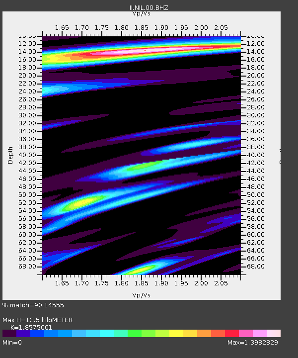
NIL Nilore, Pakistan - Earthquake Result Viewer
| Earthquake location: |
Southeast Indian Ridge |
| Earthquake latitude/longitude: |
-47.7/85.2 |
| Earthquake time(UTC): |
2015/12/04 (338) 22:24:54 GMT |
| Earthquake Depth: |
10 km |
| Earthquake Magnitude: |
7.1 MWP |
| Earthquake Catalog/Contributor: |
NEIC PDE/NEIC COMCAT |
|
| Network: |
II Global Seismograph Network (GSN - IRIS/IDA) |
| Station: |
NIL Nilore, Pakistan |
| Lat/Lon: |
33.65 N/73.27 E |
| Elevation: |
629 m |
|
| Distance: |
81.7 deg |
| Az: |
349.978 deg |
| Baz: |
171.905 deg |
| Ray Param: |
0.047385212 |
| Estimated Moho Depth: |
13.5 km |
| Estimated Crust Vp/Vs: |
1.86 |
| Assumed Crust Vp: |
6.242 km/s |
| Estimated Crust Vs: |
3.36 km/s |
| Estimated Crust Poisson's Ratio: |
0.30 |
|
| Radial Match: |
90.14555 % |
| Radial Bump: |
400 |
| Transverse Match: |
84.69026 % |
| Transverse Bump: |
400 |
| SOD ConfigId: |
1259291 |
| Insert Time: |
2015-12-18 23:14:46.471 +0000 |
| GWidth: |
2.5 |
| Max Bumps: |
400 |
| Tol: |
0.001 |
|

Signal To Noise
| Channel | StoN | STA | LTA |
| II:NIL:00:BHZ:20151204T22:36:41.718975Z | 43.709213 | 3.5954063E-6 | 8.22574E-8 |
| II:NIL:00:BH1:20151204T22:36:41.718975Z | 10.882584 | 8.809781E-7 | 8.0953036E-8 |
| II:NIL:00:BH2:20151204T22:36:41.718975Z | 3.6541522 | 3.5656453E-7 | 9.757791E-8 |
| Arrivals |
| Ps | 1.9 SECOND |
| PpPs | 6.0 SECOND |
| PsPs/PpSs | 7.9 SECOND |


