You are here: Home > Network List > II - Global Seismograph Network (GSN - IRIS/IDA) Stations List
> Station WRAB Tennant Creek, NT, Australia > Earthquake Result Viewer
WRAB Tennant Creek, NT, Australia - Earthquake Result Viewer
| Earthquake location: |
Southeast Indian Ridge |
| Earthquake latitude/longitude: |
-47.7/85.2 |
| Earthquake time(UTC): |
2015/12/04 (338) 22:24:54 GMT |
| Earthquake Depth: |
10 km |
| Earthquake Magnitude: |
7.1 MWP |
| Earthquake Catalog/Contributor: |
NEIC PDE/NEIC COMCAT |
|
| Network: |
II Global Seismograph Network (GSN - IRIS/IDA) |
| Station: |
WRAB Tennant Creek, NT, Australia |
| Lat/Lon: |
19.93 S/134.36 E |
| Elevation: |
366 m |
|
| Distance: |
48.3 deg |
| Az: |
72.458 deg |
| Baz: |
223.162 deg |
| Ray Param: |
0.06944778 |
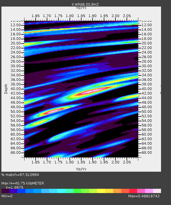
| Estimated Moho Depth: |
40.75 km |
| Estimated Crust Vp/Vs: |
1.90 |
| Assumed Crust Vp: |
6.642 km/s |
| Estimated Crust Vs: |
3.5 km/s |
| Estimated Crust Poisson's Ratio: |
0.31 |
|
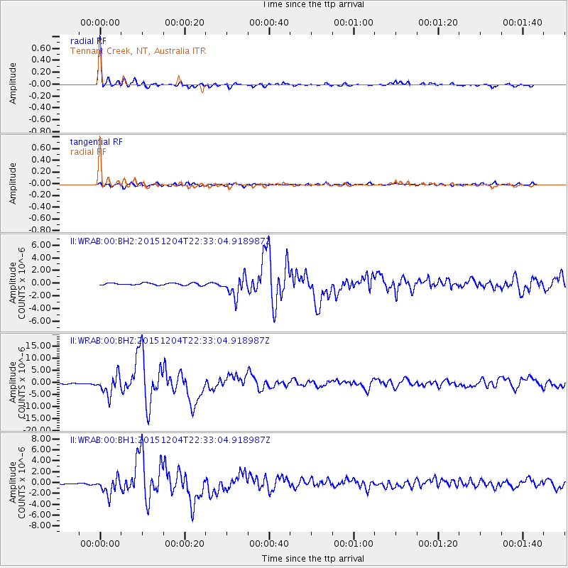
| Radial Match: |
97.510994 % |
| Radial Bump: |
320 |
| Transverse Match: |
84.85076 % |
| Transverse Bump: |
400 |
| SOD ConfigId: |
1259291 |
| Insert Time: |
2015-12-18 23:14:56.197 +0000 |
| GWidth: |
2.5 |
| Max Bumps: |
400 |
| Tol: |
0.001 |
|
Signal To Noise
| Channel | StoN | STA | LTA |
| II:WRAB:00:BHZ:20151204T22:33:04.918987Z | 33.539585 | 4.0945256E-6 | 1.220804E-7 |
| II:WRAB:00:BH1:20151204T22:33:04.918987Z | 12.58075 | 1.5952021E-6 | 1.2679705E-7 |
| II:WRAB:00:BH2:20151204T22:33:04.918987Z | 9.288382 | 1.5974184E-6 | 1.7198029E-7 |
| Arrivals |
| Ps | 5.8 SECOND |
| PpPs | 17 SECOND |
| PsPs/PpSs | 23 SECOND |


