You are here: Home > Network List > CI - Caltech Regional Seismic Network Stations List
> Station MWC Mt. Wilson Observatory, Altadena, CA, USA > Earthquake Result Viewer
MWC Mt. Wilson Observatory, Altadena, CA, USA - Earthquake Result Viewer
| Earthquake location: |
Off East Coast Of Honshu, Japan |
| Earthquake latitude/longitude: |
38.1/144.9 |
| Earthquake time(UTC): |
2005/11/14 (318) 21:38:51 GMT |
| Earthquake Depth: |
11 km |
| Earthquake Magnitude: |
6.7 MB, 6.8 MS, 7.0 MW, 6.9 MW |
| Earthquake Catalog/Contributor: |
WHDF/NEIC |
|
| Network: |
CI Caltech Regional Seismic Network |
| Station: |
MWC Mt. Wilson Observatory, Altadena, CA, USA |
| Lat/Lon: |
34.22 N/118.06 W |
| Elevation: |
1725 m |
|
| Distance: |
74.7 deg |
| Az: |
58.491 deg |
| Baz: |
305.74 deg |
| Ray Param: |
0.052155755 |
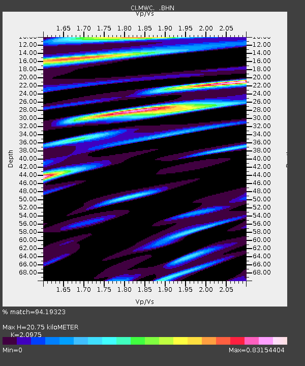
| Estimated Moho Depth: |
20.75 km |
| Estimated Crust Vp/Vs: |
2.10 |
| Assumed Crust Vp: |
6.1 km/s |
| Estimated Crust Vs: |
2.908 km/s |
| Estimated Crust Poisson's Ratio: |
0.35 |
|
| Radial Match: |
94.19323 % |
| Radial Bump: |
400 |
| Transverse Match: |
94.449936 % |
| Transverse Bump: |
400 |
| SOD ConfigId: |
2448 |
| Insert Time: |
2010-02-26 01:11:43.163 +0000 |
| GWidth: |
2.5 |
| Max Bumps: |
400 |
| Tol: |
0.001 |
|

Signal To Noise
| Channel | StoN | STA | LTA |
| CI:MWC: :BHN:20051114T21:49:59.690996Z | 3.3286486 | 7.425844E-7 | 2.2308886E-7 |
| CI:MWC: :BHE:20051114T21:49:59.690996Z | 2.199175 | 6.3128465E-7 | 2.8705523E-7 |
| CI:MWC: :BHZ:20051114T21:49:59.690996Z | 15.0437565 | 2.5344182E-6 | 1.6846977E-7 |
| Arrivals |
| Ps | 3.8 SECOND |
| PpPs | 10 SECOND |
| PsPs/PpSs | 14 SECOND |


