You are here: Home > Network List > TA - USArray Transportable Network (new EarthScope stations) Stations List
> Station X30A Coker Ranch, Turkey, TX, USA > Earthquake Result Viewer
X30A Coker Ranch, Turkey, TX, USA - Earthquake Result Viewer
| Earthquake location: |
Southeast Of Honshu, Japan |
| Earthquake latitude/longitude: |
32.8/140.4 |
| Earthquake time(UTC): |
2009/08/12 (224) 22:48:51 GMT |
| Earthquake Depth: |
53 km |
| Earthquake Magnitude: |
6.2 MB, 6.6 MW, 6.6 MW |
| Earthquake Catalog/Contributor: |
WHDF/NEIC |
|
| Network: |
TA USArray Transportable Network (new EarthScope stations) |
| Station: |
X30A Coker Ranch, Turkey, TX, USA |
| Lat/Lon: |
34.45 N/100.87 W |
| Elevation: |
698 m |
|
| Distance: |
91.8 deg |
| Az: |
46.471 deg |
| Baz: |
312.379 deg |
| Ray Param: |
0.04154245 |
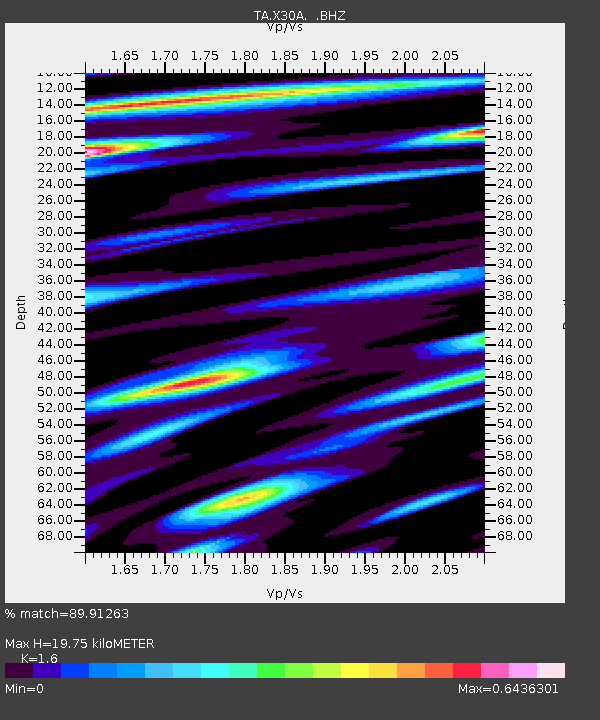
| Estimated Moho Depth: |
19.75 km |
| Estimated Crust Vp/Vs: |
1.60 |
| Assumed Crust Vp: |
6.426 km/s |
| Estimated Crust Vs: |
4.016 km/s |
| Estimated Crust Poisson's Ratio: |
0.18 |
|
| Radial Match: |
89.91263 % |
| Radial Bump: |
400 |
| Transverse Match: |
80.56813 % |
| Transverse Bump: |
400 |
| SOD ConfigId: |
2622 |
| Insert Time: |
2010-03-05 23:53:37.397 +0000 |
| GWidth: |
2.5 |
| Max Bumps: |
400 |
| Tol: |
0.001 |
|

Signal To Noise
| Channel | StoN | STA | LTA |
| TA:X30A: :BHZ:20090812T23:01:22.125017Z | 19.365433 | 1.3335422E-6 | 6.8861986E-8 |
| TA:X30A: :BHN:20090812T23:01:22.125017Z | 6.1818166 | 3.1298512E-7 | 5.0629964E-8 |
| TA:X30A: :BHE:20090812T23:01:22.125017Z | 5.3621182 | 3.601453E-7 | 6.716474E-8 |
| Arrivals |
| Ps | 1.9 SECOND |
| PpPs | 7.8 SECOND |
| PsPs/PpSs | 9.7 SECOND |


