You are here: Home > Network List > IU - Global Seismograph Network (GSN - IRIS/USGS) Stations List
> Station FURI Mt. Furi, Ethiopia > Earthquake Result Viewer
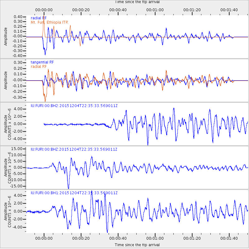
FURI Mt. Furi, Ethiopia - Earthquake Result Viewer
*The percent match for this event was below the threshold and hence no stack was calculated.
| Earthquake location: |
Southeast Indian Ridge |
| Earthquake latitude/longitude: |
-47.7/85.2 |
| Earthquake time(UTC): |
2015/12/04 (338) 22:24:54 GMT |
| Earthquake Depth: |
10 km |
| Earthquake Magnitude: |
7.1 MWP |
| Earthquake Catalog/Contributor: |
NEIC PDE/NEIC COMCAT |
|
| Network: |
IU Global Seismograph Network (GSN - IRIS/USGS) |
| Station: |
FURI Mt. Furi, Ethiopia |
| Lat/Lon: |
8.90 N/38.68 E |
| Elevation: |
2570 m |
|
| Distance: |
69.8 deg |
| Az: |
310.19 deg |
| Baz: |
148.546 deg |
| Ray Param: |
$rayparam |
*The percent match for this event was below the threshold and hence was not used in the summary stack. |
|
| Radial Match: |
91.884636 % |
| Radial Bump: |
400 |
| Transverse Match: |
92.0971 % |
| Transverse Bump: |
400 |
| SOD ConfigId: |
1259291 |
| Insert Time: |
2015-12-18 23:15:04.186 +0000 |
| GWidth: |
2.5 |
| Max Bumps: |
400 |
| Tol: |
0.001 |
|
Signal To Noise
| Channel | StoN | STA | LTA |
| IU:FURI:00:BHZ:20151204T22:35:33.569011Z | 9.596387 | 1.3549064E-6 | 1.4118923E-7 |
| IU:FURI:00:BH1:20151204T22:35:33.569011Z | 3.5814016 | 4.803263E-7 | 1.3411686E-7 |
| IU:FURI:00:BH2:20151204T22:35:33.569011Z | 2.9180994 | 2.4991178E-7 | 8.564197E-8 |
| Arrivals |
| Ps | |
| PpPs | |
| PsPs/PpSs | |


