You are here: Home > Network List > TA - USArray Transportable Network (new EarthScope stations) Stations List
> Station X30A Coker Ranch, Turkey, TX, USA > Earthquake Result Viewer
X30A Coker Ranch, Turkey, TX, USA - Earthquake Result Viewer
| Earthquake location: |
Samoa Islands Region |
| Earthquake latitude/longitude: |
-15.5/-172.1 |
| Earthquake time(UTC): |
2009/09/29 (272) 17:48:10 GMT |
| Earthquake Depth: |
18 km |
| Earthquake Magnitude: |
7.1 MB, 8.1 MS, 8.1 MW, 8.0 MW |
| Earthquake Catalog/Contributor: |
WHDF/NEIC |
|
| Network: |
TA USArray Transportable Network (new EarthScope stations) |
| Station: |
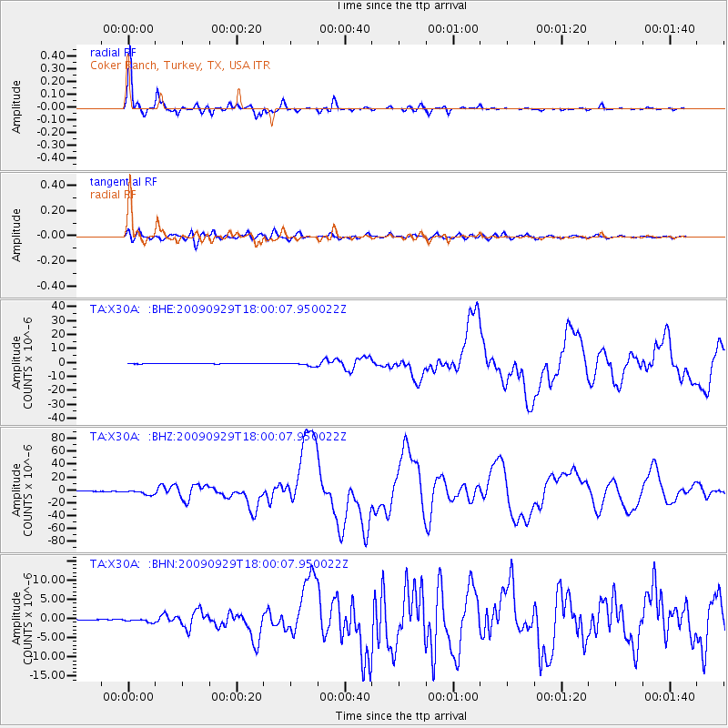
X30A Coker Ranch, Turkey, TX, USA |
| Lat/Lon: |
34.45 N/100.87 W |
| Elevation: |
698 m |
|
| Distance: |
83.9 deg |
| Az: |
51.902 deg |
| Baz: |
246.649 deg |
| Ray Param: |
0.045878053 |
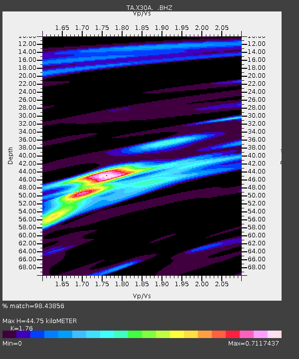
| Estimated Moho Depth: |
44.75 km |
| Estimated Crust Vp/Vs: |
1.76 |
| Assumed Crust Vp: |
6.426 km/s |
| Estimated Crust Vs: |
3.651 km/s |
| Estimated Crust Poisson's Ratio: |
0.26 |
|
| Radial Match: |
98.43856 % |
| Radial Bump: |
341 |
| Transverse Match: |
92.09902 % |
| Transverse Bump: |
400 |
| SOD ConfigId: |
2622 |
| Insert Time: |
2010-03-05 23:53:43.415 +0000 |
| GWidth: |
2.5 |
| Max Bumps: |
400 |
| Tol: |
0.001 |
|
Signal To Noise
| Channel | StoN | STA | LTA |
| TA:X30A: :BHZ:20090929T18:00:07.950022Z | 20.352274 | 3.5088106E-6 | 1.7240386E-7 |
| TA:X30A: :BHN:20090929T18:00:07.950022Z | 4.8693037 | 4.5667565E-7 | 9.3786646E-8 |
| TA:X30A: :BHE:20090929T18:00:07.950022Z | 9.717777 | 1.2039278E-6 | 1.2388922E-7 |
| Arrivals |
| Ps | 5.4 SECOND |
| PpPs | 19 SECOND |
| PsPs/PpSs | 24 SECOND |


