You are here: Home > Network List > TA - USArray Transportable Network (new EarthScope stations) Stations List
> Station X30A Coker Ranch, Turkey, TX, USA > Earthquake Result Viewer
X30A Coker Ranch, Turkey, TX, USA - Earthquake Result Viewer
| Earthquake location: |
Tonga Islands |
| Earthquake latitude/longitude: |
-16.3/-173.5 |
| Earthquake time(UTC): |
2009/10/02 (275) 01:07:39 GMT |
| Earthquake Depth: |
8.0 km |
| Earthquake Magnitude: |
6.1 MB, 6.0 MS, 6.1 MW, 6.1 MW |
| Earthquake Catalog/Contributor: |
WHDF/NEIC |
|
| Network: |
TA USArray Transportable Network (new EarthScope stations) |
| Station: |
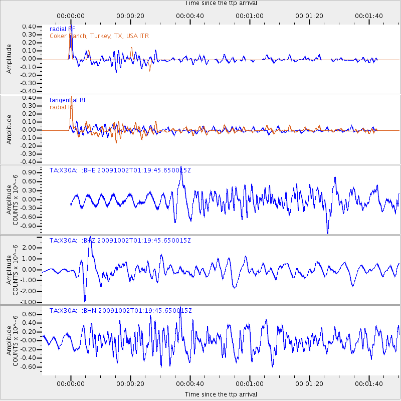
X30A Coker Ranch, Turkey, TX, USA |
| Lat/Lon: |
34.45 N/100.87 W |
| Elevation: |
698 m |
|
| Distance: |
85.4 deg |
| Az: |
52.291 deg |
| Baz: |
246.799 deg |
| Ray Param: |
0.04478442 |
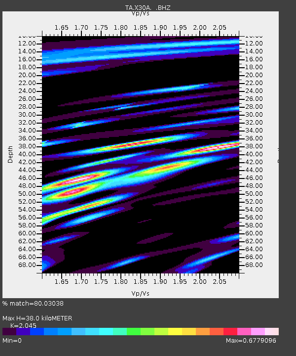
| Estimated Moho Depth: |
38.0 km |
| Estimated Crust Vp/Vs: |
2.05 |
| Assumed Crust Vp: |
6.426 km/s |
| Estimated Crust Vs: |
3.142 km/s |
| Estimated Crust Poisson's Ratio: |
0.34 |
|
| Radial Match: |
80.03038 % |
| Radial Bump: |
400 |
| Transverse Match: |
51.058323 % |
| Transverse Bump: |
400 |
| SOD ConfigId: |
2622 |
| Insert Time: |
2010-03-05 23:53:45.595 +0000 |
| GWidth: |
2.5 |
| Max Bumps: |
400 |
| Tol: |
0.001 |
|
Signal To Noise
| Channel | StoN | STA | LTA |
| TA:X30A: :BHZ:20091002T01:19:45.650015Z | 10.63634 | 8.674105E-7 | 8.15516E-8 |
| TA:X30A: :BHN:20091002T01:19:45.650015Z | 1.7651173 | 1.7777762E-7 | 1.0071717E-7 |
| TA:X30A: :BHE:20091002T01:19:45.650015Z | 1.6742204 | 2.2389433E-7 | 1.337305E-7 |
| Arrivals |
| Ps | 6.3 SECOND |
| PpPs | 18 SECOND |
| PsPs/PpSs | 24 SECOND |


