You are here: Home > Network List > IU - Global Seismograph Network (GSN - IRIS/USGS) Stations List
> Station TSUM Tsumeb, Namibia > Earthquake Result Viewer
TSUM Tsumeb, Namibia - Earthquake Result Viewer

| Earthquake location: |
Southeast Indian Ridge |
| Earthquake latitude/longitude: |
-47.7/85.2 |
| Earthquake time(UTC): |
2015/12/04 (338) 22:24:54 GMT |
| Earthquake Depth: |
10 km |
| Earthquake Magnitude: |
7.1 MWP |
| Earthquake Catalog/Contributor: |
NEIC PDE/NEIC COMCAT |
|
| Network: |
IU Global Seismograph Network (GSN - IRIS/USGS) |
| Station: |
TSUM Tsumeb, Namibia |
| Lat/Lon: |
19.20 S/17.58 E |
| Elevation: |
1260 m |
|
| Distance: |
61.0 deg |
| Az: |
272.952 deg |
| Baz: |
134.499 deg |
| Ray Param: |
0.061139356 |
| Estimated Moho Depth: |
41.25 km |
| Estimated Crust Vp/Vs: |
1.66 |
| Assumed Crust Vp: |
6.51 km/s |
| Estimated Crust Vs: |
3.922 km/s |
| Estimated Crust Poisson's Ratio: |
0.22 |
|
| Radial Match: |
96.54491 % |
| Radial Bump: |
383 |
| Transverse Match: |
80.65491 % |
| Transverse Bump: |
400 |
| SOD ConfigId: |
1259291 |
| Insert Time: |
2015-12-18 23:15:39.747 +0000 |
| GWidth: |
2.5 |
| Max Bumps: |
400 |
| Tol: |
0.001 |
|
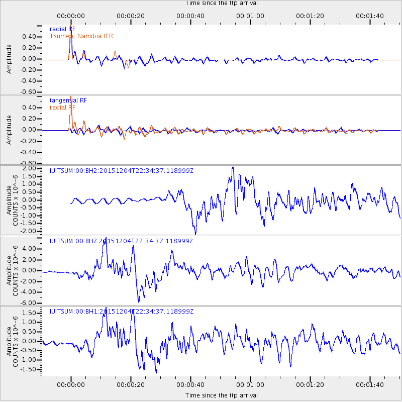
Signal To Noise
| Channel | StoN | STA | LTA |
| IU:TSUM:00:BHZ:20151204T22:34:37.118999Z | 8.292697 | 6.0405154E-7 | 7.284139E-8 |
| IU:TSUM:00:BH1:20151204T22:34:37.118999Z | 2.9329634 | 2.4375316E-7 | 8.3108155E-8 |
| IU:TSUM:00:BH2:20151204T22:34:37.118999Z | 2.3844156 | 2.7570087E-7 | 1.1562618E-7 |
| Arrivals |
| Ps | 4.4 SECOND |
| PpPs | 16 SECOND |
| PsPs/PpSs | 20 SECOND |


