You are here: Home > Network List > TJ - Tajikistan National Seismic Network Stations List
> Station SHAA Shaartuz, Tajikistan > Earthquake Result Viewer
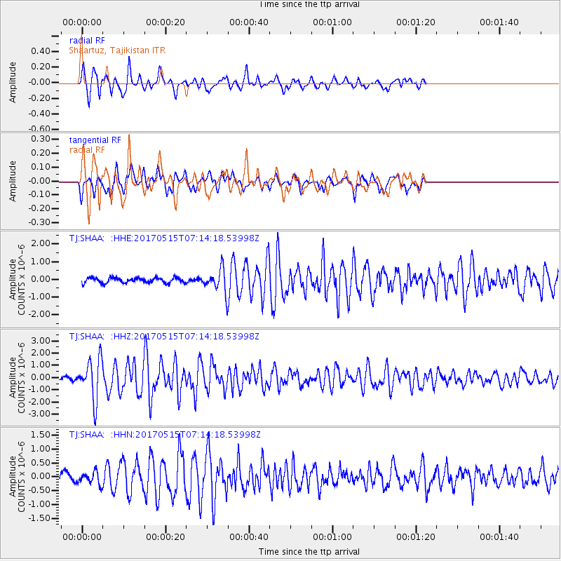
SHAA Shaartuz, Tajikistan - Earthquake Result Viewer

| Earthquake location: |
Ryukyu Islands, Japan |
| Earthquake latitude/longitude: |
27.2/130.2 |
| Earthquake time(UTC): |
2017/05/15 (135) 07:05:36 GMT |
| Earthquake Depth: |
10 km |
| Earthquake Magnitude: |
5.5 Mww |
| Earthquake Catalog/Contributor: |
NEIC PDE/us |
|
| Network: |
TJ Tajikistan National Seismic Network |
| Station: |
SHAA Shaartuz, Tajikistan |
| Lat/Lon: |
37.56 N/68.12 E |
| Elevation: |
868 m |
|
| Distance: |
52.6 deg |
| Az: |
297.863 deg |
| Baz: |
82.183 deg |
| Ray Param: |
0.066687725 |
| Estimated Moho Depth: |
27.0 km |
| Estimated Crust Vp/Vs: |
1.79 |
| Assumed Crust Vp: |
6.213 km/s |
| Estimated Crust Vs: |
3.466 km/s |
| Estimated Crust Poisson's Ratio: |
0.27 |
|
| Radial Match: |
88.02665 % |
| Radial Bump: |
400 |
| Transverse Match: |
82.28957 % |
| Transverse Bump: |
400 |
| SOD ConfigId: |
13570011 |
| Insert Time: |
2019-04-28 01:11:21.317 +0000 |
| GWidth: |
2.5 |
| Max Bumps: |
400 |
| Tol: |
0.001 |
|
Signal To Noise
| Channel | StoN | STA | LTA |
| TJ:SHAA: :HHZ:20170515T07:14:18.53998Z | 13.708519 | 1.6902557E-6 | 1.2329966E-7 |
| TJ:SHAA: :HHN:20170515T07:14:18.53998Z | 1.8474758 | 2.1714986E-7 | 1.17538676E-7 |
| TJ:SHAA: :HHE:20170515T07:14:18.53998Z | 4.3224993 | 6.4247416E-7 | 1.4863487E-7 |
| Arrivals |
| Ps | 3.6 SECOND |
| PpPs | 12 SECOND |
| PsPs/PpSs | 15 SECOND |


