You are here: Home > Network List > AK - Alaska Regional Network Stations List
> Station GAMB Gambell Broadband > Earthquake Result Viewer
GAMB Gambell Broadband - Earthquake Result Viewer
| Earthquake location: |
New Britain Region, P.N.G. |
| Earthquake latitude/longitude: |
-4.0/152.5 |
| Earthquake time(UTC): |
2017/05/15 (135) 13:22:38 GMT |
| Earthquake Depth: |
10 km |
| Earthquake Magnitude: |
5.8 mb |
| Earthquake Catalog/Contributor: |
NEIC PDE/us |
|
| Network: |
AK Alaska Regional Network |
| Station: |
GAMB Gambell Broadband |
| Lat/Lon: |
63.78 N/171.70 W |
| Elevation: |
10 m |
|
| Distance: |
72.7 deg |
| Az: |
15.787 deg |
| Baz: |
217.655 deg |
| Ray Param: |
0.05348493 |
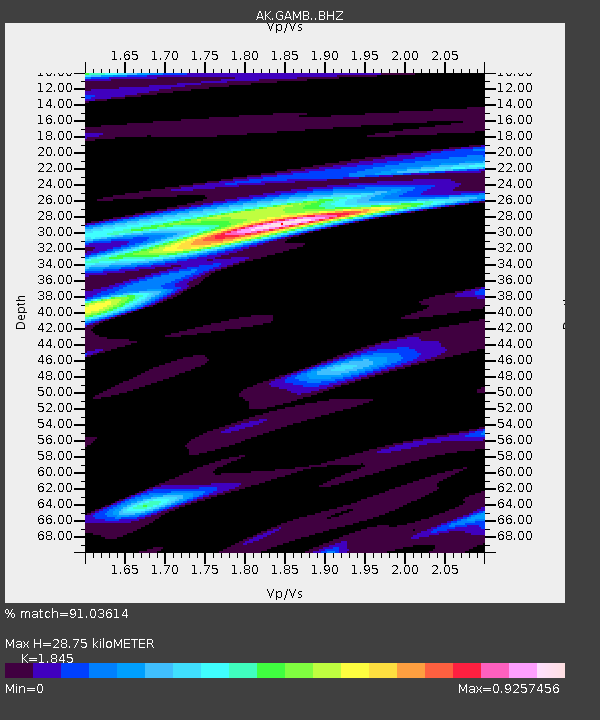
| Estimated Moho Depth: |
28.75 km |
| Estimated Crust Vp/Vs: |
1.85 |
| Assumed Crust Vp: |
6.24 km/s |
| Estimated Crust Vs: |
3.382 km/s |
| Estimated Crust Poisson's Ratio: |
0.29 |
|
| Radial Match: |
91.03614 % |
| Radial Bump: |
324 |
| Transverse Match: |
68.152626 % |
| Transverse Bump: |
400 |
| SOD ConfigId: |
13570011 |
| Insert Time: |
2019-04-28 01:12:36.146 +0000 |
| GWidth: |
2.5 |
| Max Bumps: |
400 |
| Tol: |
0.001 |
|
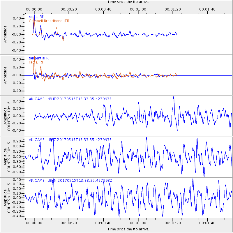
Signal To Noise
| Channel | StoN | STA | LTA |
| AK:GAMB: :BHZ:20170515T13:33:35.427993Z | 4.689737 | 3.5969907E-7 | 7.66992E-8 |
| AK:GAMB: :BHN:20170515T13:33:35.427993Z | 1.7487264 | 8.640792E-8 | 4.9411916E-8 |
| AK:GAMB: :BHE:20170515T13:33:35.427993Z | 1.70035 | 7.3879555E-8 | 4.3449614E-8 |
| Arrivals |
| Ps | 4.0 SECOND |
| PpPs | 13 SECOND |
| PsPs/PpSs | 17 SECOND |


