You are here: Home > Network List > TA - USArray Transportable Network (new EarthScope stations) Stations List
> Station X30A Coker Ranch, Turkey, TX, USA > Earthquake Result Viewer
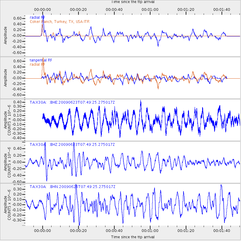
X30A Coker Ranch, Turkey, TX, USA - Earthquake Result Viewer
*The percent match for this event was below the threshold and hence no stack was calculated.
| Earthquake location: |
Near East Coast Of Honshu, Japan |
| Earthquake latitude/longitude: |
38.8/142.4 |
| Earthquake time(UTC): |
2009/06/23 (174) 07:37:17 GMT |
| Earthquake Depth: |
37 km |
| Earthquake Magnitude: |
5.7 MB, 5.0 MS, 5.6 MW, 5.6 MW |
| Earthquake Catalog/Contributor: |
WHDF/NEIC |
|
| Network: |
TA USArray Transportable Network (new EarthScope stations) |
| Station: |
X30A Coker Ranch, Turkey, TX, USA |
| Lat/Lon: |
34.45 N/100.87 W |
| Elevation: |
698 m |
|
| Distance: |
86.5 deg |
| Az: |
47.686 deg |
| Baz: |
315.679 deg |
| Ray Param: |
$rayparam |
*The percent match for this event was below the threshold and hence was not used in the summary stack. |
|
| Radial Match: |
61.765858 % |
| Radial Bump: |
400 |
| Transverse Match: |
66.62775 % |
| Transverse Bump: |
400 |
| SOD ConfigId: |
2648 |
| Insert Time: |
2010-03-05 23:54:28.704 +0000 |
| GWidth: |
2.5 |
| Max Bumps: |
400 |
| Tol: |
0.001 |
|
Signal To Noise
| Channel | StoN | STA | LTA |
| TA:X30A: :BHZ:20090623T07:49:25.275017Z | 3.742111 | 2.5097546E-7 | 6.706788E-8 |
| TA:X30A: :BHN:20090623T07:49:25.275017Z | 1.7174913 | 1.4942636E-7 | 8.700268E-8 |
| TA:X30A: :BHE:20090623T07:49:25.275017Z | 1.5625851 | 1.9592166E-7 | 1.2538304E-7 |
| Arrivals |
| Ps | |
| PpPs | |
| PsPs/PpSs | |


