You are here: Home > Network List > S - Seismographs in Schools Projects Stations List
> Station AUPKL Parklands High School, Burnie, TAS > Earthquake Result Viewer
AUPKL Parklands High School, Burnie, TAS - Earthquake Result Viewer
| Earthquake location: |
New Britain Region, P.N.G. |
| Earthquake latitude/longitude: |
-4.0/152.5 |
| Earthquake time(UTC): |
2017/05/15 (135) 13:22:38 GMT |
| Earthquake Depth: |
10 km |
| Earthquake Magnitude: |
5.8 mb |
| Earthquake Catalog/Contributor: |
NEIC PDE/us |
|
| Network: |
S Seismographs in Schools Projects |
| Station: |
AUPKL Parklands High School, Burnie, TAS |
| Lat/Lon: |
41.08 S/145.90 E |
| Elevation: |
171 m |
|
| Distance: |
37.4 deg |
| Az: |
188.248 deg |
| Baz: |
10.913 deg |
| Ray Param: |
0.07616597 |
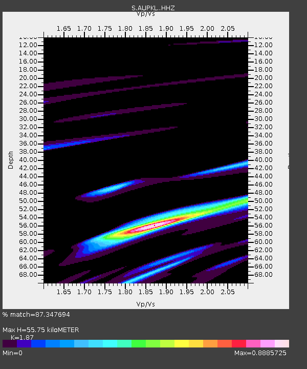
| Estimated Moho Depth: |
55.75 km |
| Estimated Crust Vp/Vs: |
1.87 |
| Assumed Crust Vp: |
6.477 km/s |
| Estimated Crust Vs: |
3.463 km/s |
| Estimated Crust Poisson's Ratio: |
0.30 |
|
| Radial Match: |
87.347694 % |
| Radial Bump: |
370 |
| Transverse Match: |
67.52426 % |
| Transverse Bump: |
400 |
| SOD ConfigId: |
13570011 |
| Insert Time: |
2019-04-28 01:15:39.545 +0000 |
| GWidth: |
2.5 |
| Max Bumps: |
400 |
| Tol: |
0.001 |
|

Signal To Noise
| Channel | StoN | STA | LTA |
| S:AUPKL: :HHZ:20170515T13:29:20.479995Z | 6.6874647 | 2.403481E-6 | 3.5940093E-7 |
| S:AUPKL: :HHN:20170515T13:29:20.479995Z | 5.538473 | 2.0886557E-6 | 3.771176E-7 |
| S:AUPKL: :HHE:20170515T13:29:20.479995Z | 2.2471492 | 1.3137286E-6 | 5.846201E-7 |
| Arrivals |
| Ps | 8.0 SECOND |
| PpPs | 23 SECOND |
| PsPs/PpSs | 31 SECOND |


