You are here: Home > Network List > TA - USArray Transportable Network (new EarthScope stations) Stations List
> Station D23K Nanushuk River, AK USA > Earthquake Result Viewer
D23K Nanushuk River, AK USA - Earthquake Result Viewer
| Earthquake location: |
New Britain Region, P.N.G. |
| Earthquake latitude/longitude: |
-4.0/152.5 |
| Earthquake time(UTC): |
2017/05/15 (135) 13:22:38 GMT |
| Earthquake Depth: |
10 km |
| Earthquake Magnitude: |
5.8 mb |
| Earthquake Catalog/Contributor: |
NEIC PDE/us |
|
| Network: |
TA USArray Transportable Network (new EarthScope stations) |
| Station: |
D23K Nanushuk River, AK USA |
| Lat/Lon: |
68.97 N/150.68 W |
| Elevation: |
406 m |
|
| Distance: |
82.4 deg |
| Az: |
17.746 deg |
| Baz: |
237.371 deg |
| Ray Param: |
0.046919603 |
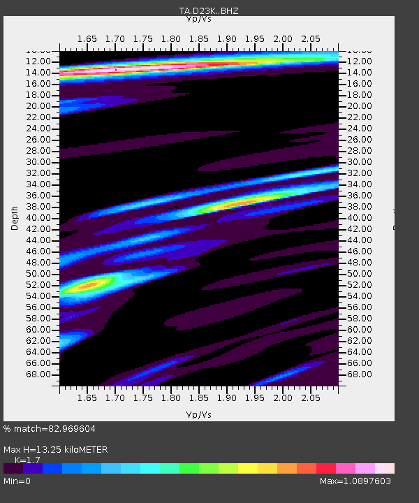
| Estimated Moho Depth: |
13.25 km |
| Estimated Crust Vp/Vs: |
1.70 |
| Assumed Crust Vp: |
6.221 km/s |
| Estimated Crust Vs: |
3.659 km/s |
| Estimated Crust Poisson's Ratio: |
0.24 |
|
| Radial Match: |
82.969604 % |
| Radial Bump: |
400 |
| Transverse Match: |
81.65268 % |
| Transverse Bump: |
400 |
| SOD ConfigId: |
13570011 |
| Insert Time: |
2019-04-28 01:15:46.761 +0000 |
| GWidth: |
2.5 |
| Max Bumps: |
400 |
| Tol: |
0.001 |
|
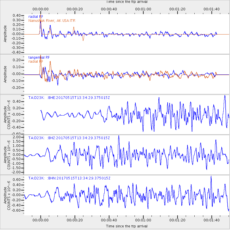
Signal To Noise
| Channel | StoN | STA | LTA |
| TA:D23K: :BHZ:20170515T13:34:29.375015Z | 2.9004853 | 3.6781483E-7 | 1.2681149E-7 |
| TA:D23K: :BHN:20170515T13:34:29.375015Z | 1.4726199 | 8.60119E-8 | 5.8407405E-8 |
| TA:D23K: :BHE:20170515T13:34:29.375015Z | 1.3127222 | 7.232273E-8 | 5.5093704E-8 |
| Arrivals |
| Ps | 1.5 SECOND |
| PpPs | 5.6 SECOND |
| PsPs/PpSs | 7.1 SECOND |


