You are here: Home > Network List > TA - USArray Transportable Network (new EarthScope stations) Stations List
> Station F21K Alatna River, AK, USA > Earthquake Result Viewer
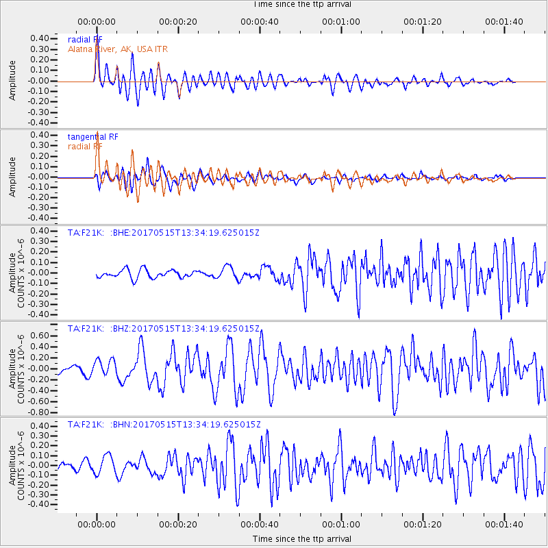
F21K Alatna River, AK, USA - Earthquake Result Viewer
*The percent match for this event was below the threshold and hence no stack was calculated.
| Earthquake location: |
New Britain Region, P.N.G. |
| Earthquake latitude/longitude: |
-4.0/152.5 |
| Earthquake time(UTC): |
2017/05/15 (135) 13:22:38 GMT |
| Earthquake Depth: |
10 km |
| Earthquake Magnitude: |
5.8 mb |
| Earthquake Catalog/Contributor: |
NEIC PDE/us |
|
| Network: |
TA USArray Transportable Network (new EarthScope stations) |
| Station: |
F21K Alatna River, AK, USA |
| Lat/Lon: |
67.22 N/153.48 W |
| Elevation: |
597 m |
|
| Distance: |
80.5 deg |
| Az: |
18.624 deg |
| Baz: |
234.903 deg |
| Ray Param: |
$rayparam |
*The percent match for this event was below the threshold and hence was not used in the summary stack. |
|
| Radial Match: |
78.7176 % |
| Radial Bump: |
400 |
| Transverse Match: |
73.093155 % |
| Transverse Bump: |
400 |
| SOD ConfigId: |
13570011 |
| Insert Time: |
2019-04-28 01:15:52.117 +0000 |
| GWidth: |
2.5 |
| Max Bumps: |
400 |
| Tol: |
0.001 |
|
Signal To Noise
| Channel | StoN | STA | LTA |
| TA:F21K: :BHZ:20170515T13:34:19.625015Z | 2.108796 | 1.4489012E-7 | 6.8707514E-8 |
| TA:F21K: :BHN:20170515T13:34:19.625015Z | 2.144375 | 9.562319E-8 | 4.4592568E-8 |
| TA:F21K: :BHE:20170515T13:34:19.625015Z | 1.5639569 | 6.085337E-8 | 3.8909874E-8 |
| Arrivals |
| Ps | |
| PpPs | |
| PsPs/PpSs | |


