You are here: Home > Network List > TA - USArray Transportable Network (new EarthScope stations) Stations List
> Station G22K Bettles, AK, USA > Earthquake Result Viewer
G22K Bettles, AK, USA - Earthquake Result Viewer
| Earthquake location: |
New Britain Region, P.N.G. |
| Earthquake latitude/longitude: |
-4.0/152.5 |
| Earthquake time(UTC): |
2017/05/15 (135) 13:22:38 GMT |
| Earthquake Depth: |
10 km |
| Earthquake Magnitude: |
5.8 mb |
| Earthquake Catalog/Contributor: |
NEIC PDE/us |
|
| Network: |
TA USArray Transportable Network (new EarthScope stations) |
| Station: |
G22K Bettles, AK, USA |
| Lat/Lon: |
66.92 N/151.51 W |
| Elevation: |
205 m |
|
| Distance: |
81.0 deg |
| Az: |
19.317 deg |
| Baz: |
236.832 deg |
| Ray Param: |
0.047884963 |
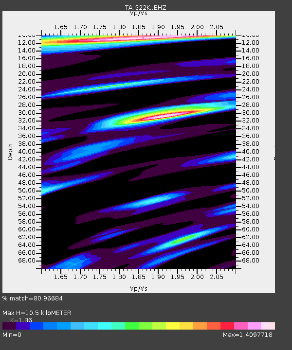
| Estimated Moho Depth: |
10.5 km |
| Estimated Crust Vp/Vs: |
1.86 |
| Assumed Crust Vp: |
6.577 km/s |
| Estimated Crust Vs: |
3.536 km/s |
| Estimated Crust Poisson's Ratio: |
0.30 |
|
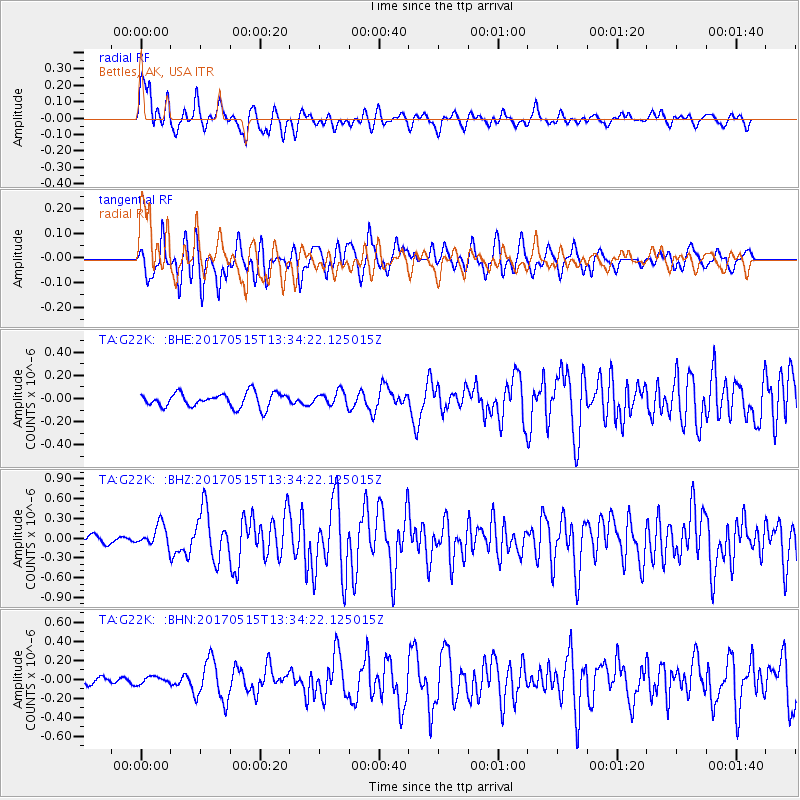
| Radial Match: |
80.96684 % |
| Radial Bump: |
400 |
| Transverse Match: |
78.908455 % |
| Transverse Bump: |
400 |
| SOD ConfigId: |
13570011 |
| Insert Time: |
2019-04-28 01:15:57.261 +0000 |
| GWidth: |
2.5 |
| Max Bumps: |
400 |
| Tol: |
0.001 |
|
Signal To Noise
| Channel | StoN | STA | LTA |
| TA:G22K: :BHZ:20170515T13:34:22.125015Z | 2.3571444 | 1.7006299E-7 | 7.214789E-8 |
| TA:G22K: :BHN:20170515T13:34:22.125015Z | 0.86957043 | 3.76241E-8 | 4.326746E-8 |
| TA:G22K: :BHE:20170515T13:34:22.125015Z | 0.9510022 | 5.9004897E-8 | 6.204496E-8 |
| Arrivals |
| Ps | 1.4 SECOND |
| PpPs | 4.4 SECOND |
| PsPs/PpSs | 5.9 SECOND |


