You are here: Home > Network List > TA - USArray Transportable Network (new EarthScope stations) Stations List
> Station J20K Nowitna River, AK, USA > Earthquake Result Viewer
J20K Nowitna River, AK, USA - Earthquake Result Viewer

| Earthquake location: |
New Britain Region, P.N.G. |
| Earthquake latitude/longitude: |
-4.0/152.5 |
| Earthquake time(UTC): |
2017/05/15 (135) 13:22:38 GMT |
| Earthquake Depth: |
10 km |
| Earthquake Magnitude: |
5.8 mb |
| Earthquake Catalog/Contributor: |
NEIC PDE/us |
|
| Network: |
TA USArray Transportable Network (new EarthScope stations) |
| Station: |
J20K Nowitna River, AK, USA |
| Lat/Lon: |
64.18 N/154.15 W |
| Elevation: |
314 m |
|
| Distance: |
78.6 deg |
| Az: |
21.005 deg |
| Baz: |
234.731 deg |
| Ray Param: |
0.04956185 |
| Estimated Moho Depth: |
63.25 km |
| Estimated Crust Vp/Vs: |
1.78 |
| Assumed Crust Vp: |
6.566 km/s |
| Estimated Crust Vs: |
3.694 km/s |
| Estimated Crust Poisson's Ratio: |
0.27 |
|
| Radial Match: |
87.42752 % |
| Radial Bump: |
325 |
| Transverse Match: |
83.06363 % |
| Transverse Bump: |
400 |
| SOD ConfigId: |
13570011 |
| Insert Time: |
2019-04-28 01:16:02.921 +0000 |
| GWidth: |
2.5 |
| Max Bumps: |
400 |
| Tol: |
0.001 |
|
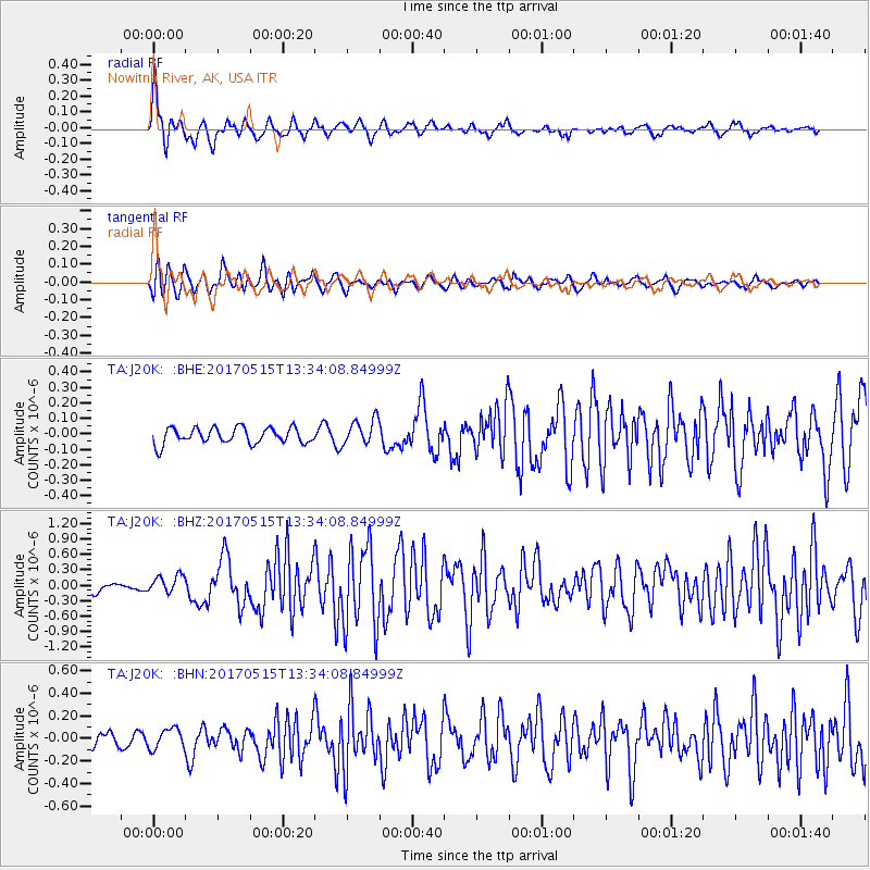
Signal To Noise
| Channel | StoN | STA | LTA |
| TA:J20K: :BHZ:20170515T13:34:08.84999Z | 1.4387436 | 1.7317862E-7 | 1.2036796E-7 |
| TA:J20K: :BHN:20170515T13:34:08.84999Z | 1.3677634 | 8.9752774E-8 | 6.562011E-8 |
| TA:J20K: :BHE:20170515T13:34:08.84999Z | 1.6167806 | 8.2655845E-8 | 5.1123724E-8 |
| Arrivals |
| Ps | 7.7 SECOND |
| PpPs | 26 SECOND |
| PsPs/PpSs | 34 SECOND |


