You are here: Home > Network List > TA - USArray Transportable Network (new EarthScope stations) Stations List
> Station 131A Roby, TX, USA > Earthquake Result Viewer
131A Roby, TX, USA - Earthquake Result Viewer
| Earthquake location: |
Near S. Coast Of Honshu, Japan |
| Earthquake latitude/longitude: |
33.2/137.9 |
| Earthquake time(UTC): |
2009/08/09 (221) 10:55:55 GMT |
| Earthquake Depth: |
297 km |
| Earthquake Magnitude: |
6.5 MB, 7.1 MW, 7.1 MW |
| Earthquake Catalog/Contributor: |
WHDF/NEIC |
|
| Network: |
TA USArray Transportable Network (new EarthScope stations) |
| Station: |
131A Roby, TX, USA |
| Lat/Lon: |
32.67 N/100.39 W |
| Elevation: |
622 m |
|
| Distance: |
94.5 deg |
| Az: |
46.058 deg |
| Baz: |
314.268 deg |
| Ray Param: |
0.04077362 |
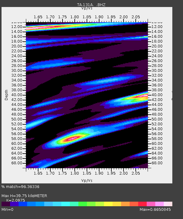
| Estimated Moho Depth: |
39.75 km |
| Estimated Crust Vp/Vs: |
2.10 |
| Assumed Crust Vp: |
6.426 km/s |
| Estimated Crust Vs: |
3.064 km/s |
| Estimated Crust Poisson's Ratio: |
0.35 |
|
| Radial Match: |
96.36336 % |
| Radial Bump: |
400 |
| Transverse Match: |
81.57751 % |
| Transverse Bump: |
400 |
| SOD ConfigId: |
2622 |
| Insert Time: |
2010-03-05 23:54:44.283 +0000 |
| GWidth: |
2.5 |
| Max Bumps: |
400 |
| Tol: |
0.001 |
|

Signal To Noise
| Channel | StoN | STA | LTA |
| TA:131A: :BHZ:20090809T11:08:11.075027Z | 65.99729 | 4.2232145E-6 | 6.3990726E-8 |
| TA:131A: :BHN:20090809T11:08:11.075027Z | 13.187713 | 7.915023E-7 | 6.0018166E-8 |
| TA:131A: :BHE:20090809T11:08:11.075027Z | 11.853397 | 8.5651976E-7 | 7.225943E-8 |
| Arrivals |
| Ps | 6.9 SECOND |
| PpPs | 19 SECOND |
| PsPs/PpSs | 26 SECOND |


