You are here: Home > Network List > TA - USArray Transportable Network (new EarthScope stations) Stations List
> Station 131A Roby, TX, USA > Earthquake Result Viewer
131A Roby, TX, USA - Earthquake Result Viewer

| Earthquake location: |
Kuril Islands |
| Earthquake latitude/longitude: |
48.3/154.2 |
| Earthquake time(UTC): |
2009/09/10 (253) 02:46:50 GMT |
| Earthquake Depth: |
36 km |
| Earthquake Magnitude: |
6.0 MB, 5.5 MS, 6.0 MW, 5.8 MW |
| Earthquake Catalog/Contributor: |
WHDF/NEIC |
|
| Network: |
TA USArray Transportable Network (new EarthScope stations) |
| Station: |
131A Roby, TX, USA |
| Lat/Lon: |
32.67 N/100.39 W |
| Elevation: |
622 m |
|
| Distance: |
75.5 deg |
| Az: |
57.118 deg |
| Baz: |
318.345 deg |
| Ray Param: |
0.05157288 |
| Estimated Moho Depth: |
32.25 km |
| Estimated Crust Vp/Vs: |
1.96 |
| Assumed Crust Vp: |
6.426 km/s |
| Estimated Crust Vs: |
3.274 km/s |
| Estimated Crust Poisson's Ratio: |
0.32 |
|
| Radial Match: |
80.62476 % |
| Radial Bump: |
322 |
| Transverse Match: |
71.38247 % |
| Transverse Bump: |
400 |
| SOD ConfigId: |
2622 |
| Insert Time: |
2010-03-05 23:54:48.532 +0000 |
| GWidth: |
2.5 |
| Max Bumps: |
400 |
| Tol: |
0.001 |
|
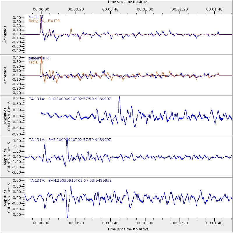
Signal To Noise
| Channel | StoN | STA | LTA |
| TA:131A: :BHZ:20090910T02:57:59.948999Z | 8.308944 | 8.77727E-7 | 1.0563641E-7 |
| TA:131A: :BHN:20090910T02:57:59.948999Z | 2.3903766 | 2.3600197E-7 | 9.873004E-8 |
| TA:131A: :BHE:20090910T02:57:59.948999Z | 2.0005338 | 1.9463005E-7 | 9.728906E-8 |
| Arrivals |
| Ps | 5.0 SECOND |
| PpPs | 14 SECOND |
| PsPs/PpSs | 19 SECOND |


