You are here: Home > Network List > IU - Global Seismograph Network (GSN - IRIS/USGS) Stations List
> Station PMG Port Moresby, New Guinea > Earthquake Result Viewer
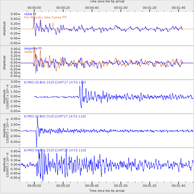
PMG Port Moresby, New Guinea - Earthquake Result Viewer
*The percent match for this event was below the threshold and hence no stack was calculated.
| Earthquake location: |
Fiji Islands Region |
| Earthquake latitude/longitude: |
-18.2/-178.7 |
| Earthquake time(UTC): |
2015/12/06 (340) 17:09:28 GMT |
| Earthquake Depth: |
544 km |
| Earthquake Magnitude: |
5.8 MB |
| Earthquake Catalog/Contributor: |
NEIC PDE/NEIC COMCAT |
|
| Network: |
IU Global Seismograph Network (GSN - IRIS/USGS) |
| Station: |
PMG Port Moresby, New Guinea |
| Lat/Lon: |
9.40 S/147.16 E |
| Elevation: |
90 m |
|
| Distance: |
34.3 deg |
| Az: |
280.132 deg |
| Baz: |
108.487 deg |
| Ray Param: |
$rayparam |
*The percent match for this event was below the threshold and hence was not used in the summary stack. |
|
| Radial Match: |
88.11426 % |
| Radial Bump: |
400 |
| Transverse Match: |
83.05197 % |
| Transverse Bump: |
400 |
| SOD ConfigId: |
1259291 |
| Insert Time: |
2015-12-20 17:48:28.942 +0000 |
| GWidth: |
2.5 |
| Max Bumps: |
400 |
| Tol: |
0.001 |
|
Signal To Noise
| Channel | StoN | STA | LTA |
| IU:PMG:00:BHZ:20151206T17:14:59.119Z | 20.749302 | 1.8747261E-6 | 9.0351286E-8 |
| IU:PMG:00:BH1:20151206T17:14:59.119Z | 5.8559284 | 4.4029056E-7 | 7.518715E-8 |
| IU:PMG:00:BH2:20151206T17:14:59.119Z | 18.599188 | 1.2407489E-6 | 6.6709845E-8 |
| Arrivals |
| Ps | |
| PpPs | |
| PsPs/PpSs | |


