You are here: Home > Network List > BK - Berkeley Digital Seismograph Network Stations List
> Station HUMO Hull Mountain, OR > Earthquake Result Viewer
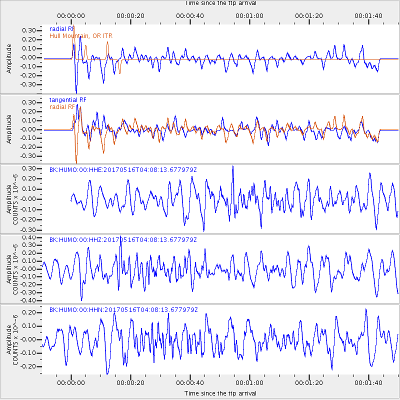
HUMO Hull Mountain, OR - Earthquake Result Viewer
*The percent match for this event was below the threshold and hence no stack was calculated.
| Earthquake location: |
South Of Mariana Islands |
| Earthquake latitude/longitude: |
12.4/145.1 |
| Earthquake time(UTC): |
2017/05/16 (136) 03:56:22 GMT |
| Earthquake Depth: |
40 km |
| Earthquake Magnitude: |
5.5 Mi |
| Earthquake Catalog/Contributor: |
NEIC PDE/pt |
|
| Network: |
BK Berkeley Digital Seismograph Network |
| Station: |
HUMO Hull Mountain, OR |
| Lat/Lon: |
42.61 N/122.96 W |
| Elevation: |
555 m |
|
| Distance: |
83.1 deg |
| Az: |
48.006 deg |
| Baz: |
280.388 deg |
| Ray Param: |
$rayparam |
*The percent match for this event was below the threshold and hence was not used in the summary stack. |
|
| Radial Match: |
57.898228 % |
| Radial Bump: |
400 |
| Transverse Match: |
46.345203 % |
| Transverse Bump: |
400 |
| SOD ConfigId: |
13570011 |
| Insert Time: |
2019-04-28 01:20:52.097 +0000 |
| GWidth: |
2.5 |
| Max Bumps: |
400 |
| Tol: |
0.001 |
|
Signal To Noise
| Channel | StoN | STA | LTA |
| BK:HUMO:00:HHZ:20170516T04:08:13.677979Z | 2.0597003 | 1.7353321E-7 | 8.425168E-8 |
| BK:HUMO:00:HHN:20170516T04:08:13.677979Z | 0.76137286 | 6.958571E-8 | 9.1395044E-8 |
| BK:HUMO:00:HHE:20170516T04:08:13.677979Z | 1.0583444 | 8.9241205E-8 | 8.432152E-8 |
| Arrivals |
| Ps | |
| PpPs | |
| PsPs/PpSs | |


