You are here: Home > Network List > US - United States National Seismic Network Stations List
> Station MSO Missoula, Montana, USA > Earthquake Result Viewer
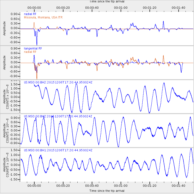
MSO Missoula, Montana, USA - Earthquake Result Viewer
*The percent match for this event was below the threshold and hence no stack was calculated.
| Earthquake location: |
Fiji Islands Region |
| Earthquake latitude/longitude: |
-18.2/-178.7 |
| Earthquake time(UTC): |
2015/12/06 (340) 17:09:28 GMT |
| Earthquake Depth: |
544 km |
| Earthquake Magnitude: |
5.8 MB |
| Earthquake Catalog/Contributor: |
NEIC PDE/NEIC COMCAT |
|
| Network: |
US United States National Seismic Network |
| Station: |
MSO Missoula, Montana, USA |
| Lat/Lon: |
46.83 N/113.94 W |
| Elevation: |
1264 m |
|
| Distance: |
87.0 deg |
| Az: |
38.45 deg |
| Baz: |
239.423 deg |
| Ray Param: |
$rayparam |
*The percent match for this event was below the threshold and hence was not used in the summary stack. |
|
| Radial Match: |
71.22119 % |
| Radial Bump: |
400 |
| Transverse Match: |
68.61821 % |
| Transverse Bump: |
389 |
| SOD ConfigId: |
1259291 |
| Insert Time: |
2015-12-20 17:50:18.499 +0000 |
| GWidth: |
2.5 |
| Max Bumps: |
400 |
| Tol: |
0.001 |
|
Signal To Noise
| Channel | StoN | STA | LTA |
| US:MSO:00:BHZ:20151206T17:20:44.950024Z | 1.1407118 | 6.354138E-7 | 5.5703276E-7 |
| US:MSO:00:BH1:20151206T17:20:44.950024Z | 1.2847873 | 7.3884314E-7 | 5.7507043E-7 |
| US:MSO:00:BH2:20151206T17:20:44.950024Z | 1.5164043 | 1.292104E-6 | 8.520841E-7 |
| Arrivals |
| Ps | |
| PpPs | |
| PsPs/PpSs | |


