You are here: Home > Network List > TA - USArray Transportable Network (new EarthScope stations) Stations List
> Station D25K Kavik River, AK, USA > Earthquake Result Viewer
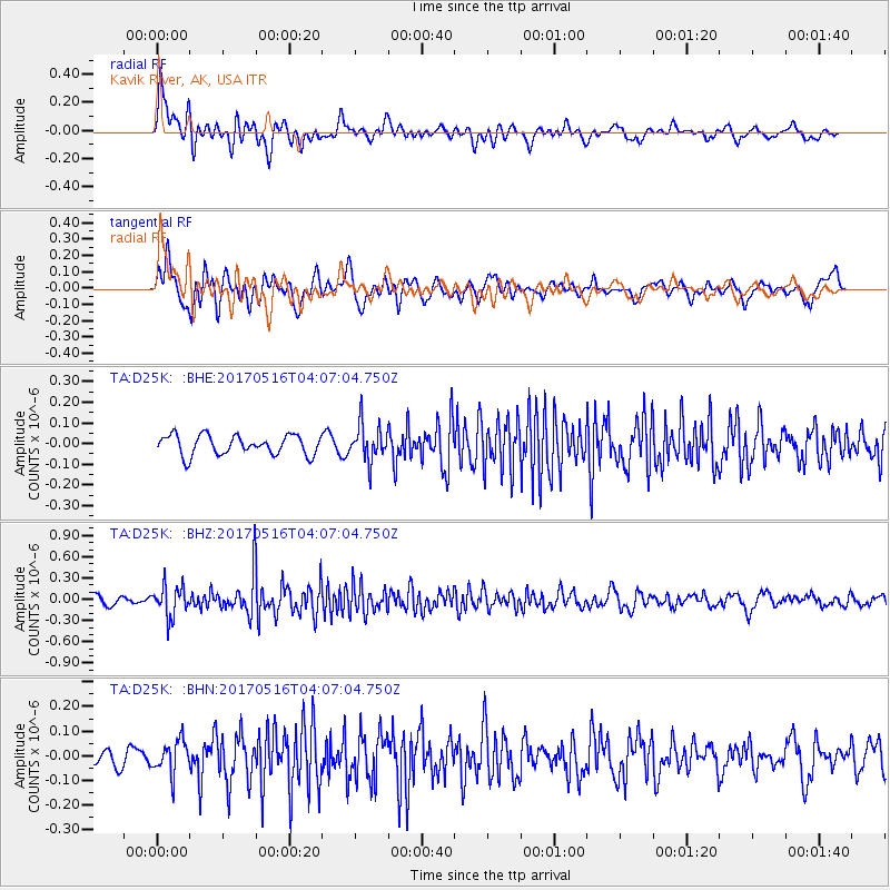
D25K Kavik River, AK, USA - Earthquake Result Viewer
*The percent match for this event was below the threshold and hence no stack was calculated.
| Earthquake location: |
South Of Mariana Islands |
| Earthquake latitude/longitude: |
12.4/145.1 |
| Earthquake time(UTC): |
2017/05/16 (136) 03:56:22 GMT |
| Earthquake Depth: |
40 km |
| Earthquake Magnitude: |
5.5 Mi |
| Earthquake Catalog/Contributor: |
NEIC PDE/pt |
|
| Network: |
TA USArray Transportable Network (new EarthScope stations) |
| Station: |
D25K Kavik River, AK, USA |
| Lat/Lon: |
69.32 N/146.38 W |
| Elevation: |
770 m |
|
| Distance: |
71.0 deg |
| Az: |
20.461 deg |
| Baz: |
254.071 deg |
| Ray Param: |
$rayparam |
*The percent match for this event was below the threshold and hence was not used in the summary stack. |
|
| Radial Match: |
77.016815 % |
| Radial Bump: |
400 |
| Transverse Match: |
72.049545 % |
| Transverse Bump: |
400 |
| SOD ConfigId: |
13570011 |
| Insert Time: |
2019-04-28 01:23:48.291 +0000 |
| GWidth: |
2.5 |
| Max Bumps: |
400 |
| Tol: |
0.001 |
|
Signal To Noise
| Channel | StoN | STA | LTA |
| TA:D25K: :BHZ:20170516T04:07:04.750Z | 4.2589173 | 2.1475137E-7 | 5.042394E-8 |
| TA:D25K: :BHN:20170516T04:07:04.750Z | 1.9557197 | 6.768225E-8 | 3.460734E-8 |
| TA:D25K: :BHE:20170516T04:07:04.750Z | 1.8168927 | 8.6492E-8 | 4.760435E-8 |
| Arrivals |
| Ps | |
| PpPs | |
| PsPs/PpSs | |


