You are here: Home > Network List > TA - USArray Transportable Network (new EarthScope stations) Stations List
> Station J20K Nowitna River, AK, USA > Earthquake Result Viewer
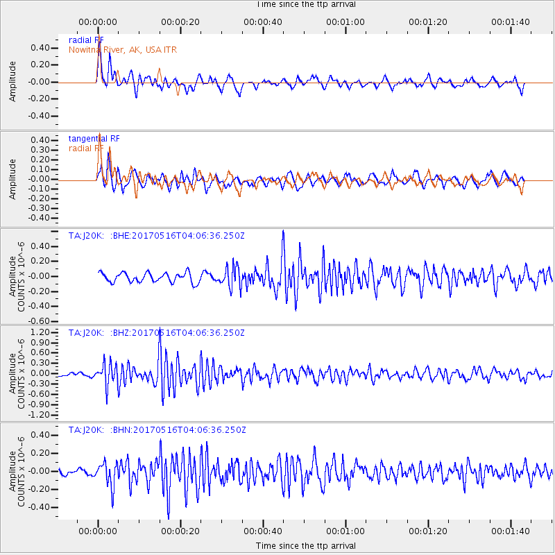
J20K Nowitna River, AK, USA - Earthquake Result Viewer
*The percent match for this event was below the threshold and hence no stack was calculated.
| Earthquake location: |
South Of Mariana Islands |
| Earthquake latitude/longitude: |
12.4/145.1 |
| Earthquake time(UTC): |
2017/05/16 (136) 03:56:22 GMT |
| Earthquake Depth: |
40 km |
| Earthquake Magnitude: |
5.5 Mi |
| Earthquake Catalog/Contributor: |
NEIC PDE/pt |
|
| Network: |
TA USArray Transportable Network (new EarthScope stations) |
| Station: |
J20K Nowitna River, AK, USA |
| Lat/Lon: |
64.18 N/154.15 W |
| Elevation: |
314 m |
|
| Distance: |
66.4 deg |
| Az: |
24.64 deg |
| Baz: |
248.451 deg |
| Ray Param: |
$rayparam |
*The percent match for this event was below the threshold and hence was not used in the summary stack. |
|
| Radial Match: |
72.18189 % |
| Radial Bump: |
400 |
| Transverse Match: |
70.56164 % |
| Transverse Bump: |
400 |
| SOD ConfigId: |
13570011 |
| Insert Time: |
2019-04-28 01:24:06.302 +0000 |
| GWidth: |
2.5 |
| Max Bumps: |
400 |
| Tol: |
0.001 |
|
Signal To Noise
| Channel | StoN | STA | LTA |
| TA:J20K: :BHZ:20170516T04:06:36.250Z | 4.48382 | 3.091534E-7 | 6.8948665E-8 |
| TA:J20K: :BHN:20170516T04:06:36.250Z | 1.7318788 | 1.2936424E-7 | 7.4695905E-8 |
| TA:J20K: :BHE:20170516T04:06:36.250Z | 2.0739768 | 1.3072226E-7 | 6.302976E-8 |
| Arrivals |
| Ps | |
| PpPs | |
| PsPs/PpSs | |


