You are here: Home > Network List > TA - USArray Transportable Network (new EarthScope stations) Stations List
> Station Y28A McKinney Farm, Littlefield, TX, USA > Earthquake Result Viewer
Y28A McKinney Farm, Littlefield, TX, USA - Earthquake Result Viewer
| Earthquake location: |
Kuril Islands |
| Earthquake latitude/longitude: |
46.0/151.4 |
| Earthquake time(UTC): |
2009/04/18 (108) 19:17:58 GMT |
| Earthquake Depth: |
35 km |
| Earthquake Magnitude: |
6.3 MB, 6.3 MS, 6.6 MW, 6.4 MW |
| Earthquake Catalog/Contributor: |
WHDF/NEIC |
|
| Network: |
TA USArray Transportable Network (new EarthScope stations) |
| Station: |
Y28A McKinney Farm, Littlefield, TX, USA |
| Lat/Lon: |
33.91 N/102.25 W |
| Elevation: |
1068 m |
|
| Distance: |
76.4 deg |
| Az: |
55.204 deg |
| Baz: |
316.519 deg |
| Ray Param: |
0.0509766 |
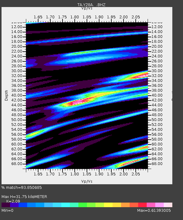
| Estimated Moho Depth: |
31.75 km |
| Estimated Crust Vp/Vs: |
2.09 |
| Assumed Crust Vp: |
6.129 km/s |
| Estimated Crust Vs: |
2.932 km/s |
| Estimated Crust Poisson's Ratio: |
0.35 |
|
| Radial Match: |
93.850685 % |
| Radial Bump: |
400 |
| Transverse Match: |
71.61953 % |
| Transverse Bump: |
400 |
| SOD ConfigId: |
2760 |
| Insert Time: |
2010-03-05 23:55:48.938 +0000 |
| GWidth: |
2.5 |
| Max Bumps: |
400 |
| Tol: |
0.001 |
|

Signal To Noise
| Channel | StoN | STA | LTA |
| TA:Y28A: :BHZ:20090418T19:29:13.70002Z | 15.851827 | 2.2131958E-6 | 1.3961771E-7 |
| TA:Y28A: :BHN:20090418T19:29:13.70002Z | 4.9847913 | 7.363826E-7 | 1.4772586E-7 |
| TA:Y28A: :BHE:20090418T19:29:13.70002Z | 4.1854763 | 7.1550414E-7 | 1.7094928E-7 |
| Arrivals |
| Ps | 5.8 SECOND |
| PpPs | 16 SECOND |
| PsPs/PpSs | 21 SECOND |


