You are here: Home > Network List > TA - USArray Transportable Network (new EarthScope stations) Stations List
> Station Y28A McKinney Farm, Littlefield, TX, USA > Earthquake Result Viewer
Y28A McKinney Farm, Littlefield, TX, USA - Earthquake Result Viewer
| Earthquake location: |
Southeast Of Honshu, Japan |
| Earthquake latitude/longitude: |
32.8/140.4 |
| Earthquake time(UTC): |
2009/08/12 (224) 22:48:51 GMT |
| Earthquake Depth: |
53 km |
| Earthquake Magnitude: |
6.2 MB, 6.6 MW, 6.6 MW |
| Earthquake Catalog/Contributor: |
WHDF/NEIC |
|
| Network: |
TA USArray Transportable Network (new EarthScope stations) |
| Station: |
Y28A McKinney Farm, Littlefield, TX, USA |
| Lat/Lon: |
33.91 N/102.25 W |
| Elevation: |
1068 m |
|
| Distance: |
91.3 deg |
| Az: |
47.632 deg |
| Baz: |
311.58 deg |
| Ray Param: |
0.04160519 |
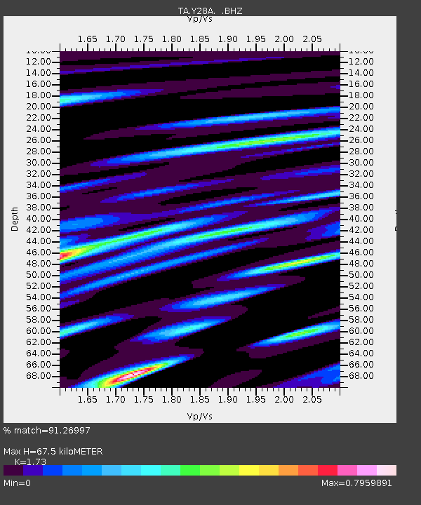
| Estimated Moho Depth: |
67.5 km |
| Estimated Crust Vp/Vs: |
1.73 |
| Assumed Crust Vp: |
6.129 km/s |
| Estimated Crust Vs: |
3.543 km/s |
| Estimated Crust Poisson's Ratio: |
0.25 |
|
| Radial Match: |
91.26997 % |
| Radial Bump: |
400 |
| Transverse Match: |
67.52968 % |
| Transverse Bump: |
400 |
| SOD ConfigId: |
2622 |
| Insert Time: |
2010-03-05 23:55:55.984 +0000 |
| GWidth: |
2.5 |
| Max Bumps: |
400 |
| Tol: |
0.001 |
|

Signal To Noise
| Channel | StoN | STA | LTA |
| TA:Y28A: :BHZ:20090812T23:01:19.849016Z | 20.248537 | 1.3315955E-6 | 6.5762556E-8 |
| TA:Y28A: :BHN:20090812T23:01:19.849016Z | 3.9670208 | 4.062398E-7 | 1.0240424E-7 |
| TA:Y28A: :BHE:20090812T23:01:19.849016Z | 3.024395 | 3.9897841E-7 | 1.3192006E-7 |
| Arrivals |
| Ps | 8.2 SECOND |
| PpPs | 29 SECOND |
| PsPs/PpSs | 38 SECOND |


