You are here: Home > Network List > TA - USArray Transportable Network (new EarthScope stations) Stations List
> Station Y28A McKinney Farm, Littlefield, TX, USA > Earthquake Result Viewer
Y28A McKinney Farm, Littlefield, TX, USA - Earthquake Result Viewer
| Earthquake location: |
Kuril Islands |
| Earthquake latitude/longitude: |
48.3/154.2 |
| Earthquake time(UTC): |
2009/09/10 (253) 02:46:50 GMT |
| Earthquake Depth: |
36 km |
| Earthquake Magnitude: |
6.0 MB, 5.5 MS, 6.0 MW, 5.8 MW |
| Earthquake Catalog/Contributor: |
WHDF/NEIC |
|
| Network: |
TA USArray Transportable Network (new EarthScope stations) |
| Station: |
Y28A McKinney Farm, Littlefield, TX, USA |
| Lat/Lon: |
33.91 N/102.25 W |
| Elevation: |
1068 m |
|
| Distance: |
73.5 deg |
| Az: |
57.46 deg |
| Baz: |
317.42 deg |
| Ray Param: |
0.052879535 |
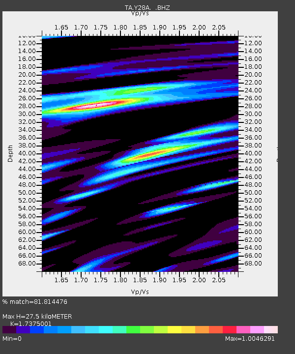
| Estimated Moho Depth: |
27.5 km |
| Estimated Crust Vp/Vs: |
1.74 |
| Assumed Crust Vp: |
6.129 km/s |
| Estimated Crust Vs: |
3.527 km/s |
| Estimated Crust Poisson's Ratio: |
0.25 |
|
| Radial Match: |
81.814476 % |
| Radial Bump: |
400 |
| Transverse Match: |
81.320114 % |
| Transverse Bump: |
400 |
| SOD ConfigId: |
2622 |
| Insert Time: |
2010-03-05 23:55:59.334 +0000 |
| GWidth: |
2.5 |
| Max Bumps: |
400 |
| Tol: |
0.001 |
|

Signal To Noise
| Channel | StoN | STA | LTA |
| TA:Y28A: :BHZ:20090910T02:57:48.625024Z | 5.8466625 | 6.622568E-7 | 1.1327092E-7 |
| TA:Y28A: :BHN:20090910T02:57:48.625024Z | 1.3008 | 2.0946143E-7 | 1.610251E-7 |
| TA:Y28A: :BHE:20090910T02:57:48.625024Z | 1.3021528 | 1.6432898E-7 | 1.2619793E-7 |
| Arrivals |
| Ps | 3.4 SECOND |
| PpPs | 12 SECOND |
| PsPs/PpSs | 15 SECOND |


