You are here: Home > Network List > TA - USArray Transportable Network (new EarthScope stations) Stations List
> Station Y28A McKinney Farm, Littlefield, TX, USA > Earthquake Result Viewer
Y28A McKinney Farm, Littlefield, TX, USA - Earthquake Result Viewer
| Earthquake location: |
Near Coast Of Venezuela |
| Earthquake latitude/longitude: |
10.7/-67.9 |
| Earthquake time(UTC): |
2009/09/12 (255) 20:06:24 GMT |
| Earthquake Depth: |
10 km |
| Earthquake Magnitude: |
6.3 MB, 6.4 MS, 6.3 MW, 6.3 MW |
| Earthquake Catalog/Contributor: |
WHDF/NEIC |
|
| Network: |
TA USArray Transportable Network (new EarthScope stations) |
| Station: |
Y28A McKinney Farm, Littlefield, TX, USA |
| Lat/Lon: |
33.91 N/102.25 W |
| Elevation: |
1068 m |
|
| Distance: |
39.0 deg |
| Az: |
311.778 deg |
| Baz: |
118.202 deg |
| Ray Param: |
0.07525506 |
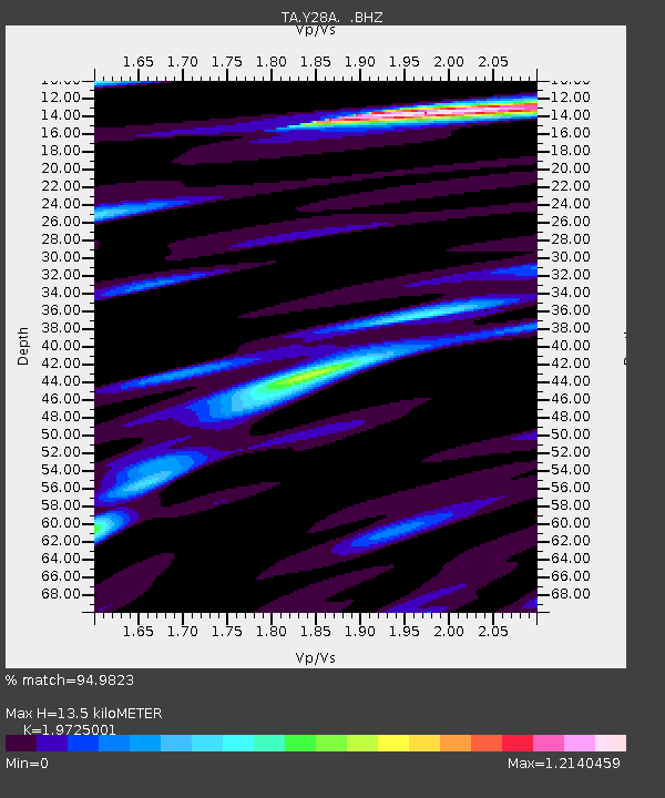
| Estimated Moho Depth: |
13.5 km |
| Estimated Crust Vp/Vs: |
1.97 |
| Assumed Crust Vp: |
6.129 km/s |
| Estimated Crust Vs: |
3.107 km/s |
| Estimated Crust Poisson's Ratio: |
0.33 |
|
| Radial Match: |
94.9823 % |
| Radial Bump: |
279 |
| Transverse Match: |
77.22107 % |
| Transverse Bump: |
400 |
| SOD ConfigId: |
2622 |
| Insert Time: |
2010-03-05 23:56:01.650 +0000 |
| GWidth: |
2.5 |
| Max Bumps: |
400 |
| Tol: |
0.001 |
|

Signal To Noise
| Channel | StoN | STA | LTA |
| TA:Y28A: :BHZ:20090912T20:13:20.050005Z | 11.301211 | 1.4364122E-6 | 1.271025E-7 |
| TA:Y28A: :BHN:20090912T20:13:20.050005Z | 4.407467 | 4.909687E-7 | 1.1139476E-7 |
| TA:Y28A: :BHE:20090912T20:13:20.050005Z | 8.669989 | 7.5835925E-7 | 8.7469466E-8 |
| Arrivals |
| Ps | 2.3 SECOND |
| PpPs | 6.2 SECOND |
| PsPs/PpSs | 8.4 SECOND |


