You are here: Home > Network List > TA - USArray Transportable Network (new EarthScope stations) Stations List
> Station Y28A McKinney Farm, Littlefield, TX, USA > Earthquake Result Viewer
Y28A McKinney Farm, Littlefield, TX, USA - Earthquake Result Viewer
| Earthquake location: |
East Of Severnaya Zemlya |
| Earthquake latitude/longitude: |
81.6/119.5 |
| Earthquake time(UTC): |
2009/10/07 (280) 20:52:13 GMT |
| Earthquake Depth: |
8.0 km |
| Earthquake Magnitude: |
5.7 MB, 5.1 MS, 5.8 MW, 5.8 MW |
| Earthquake Catalog/Contributor: |
WHDF/NEIC |
|
| Network: |
TA USArray Transportable Network (new EarthScope stations) |
| Station: |
Y28A McKinney Farm, Littlefield, TX, USA |
| Lat/Lon: |
33.91 N/102.25 W |
| Elevation: |
1068 m |
|
| Distance: |
62.8 deg |
| Az: |
38.553 deg |
| Baz: |
353.652 deg |
| Ray Param: |
0.060020335 |
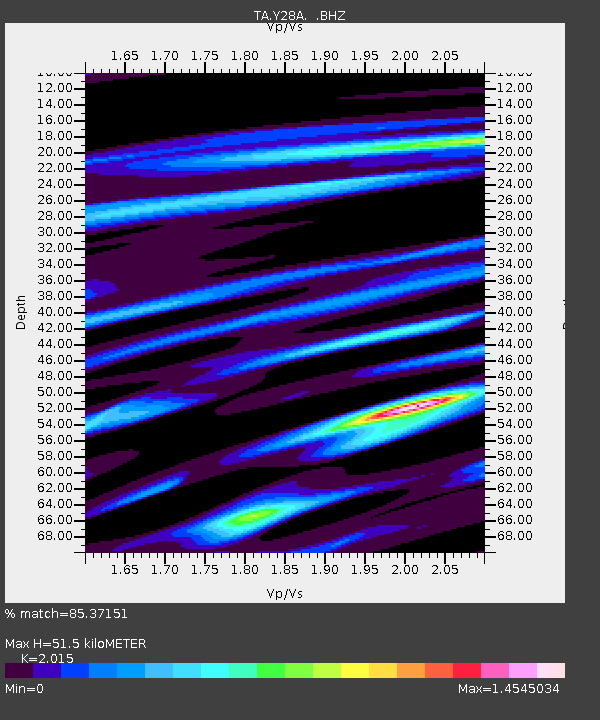
| Estimated Moho Depth: |
51.5 km |
| Estimated Crust Vp/Vs: |
2.02 |
| Assumed Crust Vp: |
6.129 km/s |
| Estimated Crust Vs: |
3.042 km/s |
| Estimated Crust Poisson's Ratio: |
0.34 |
|
| Radial Match: |
85.37151 % |
| Radial Bump: |
400 |
| Transverse Match: |
81.49236 % |
| Transverse Bump: |
400 |
| SOD ConfigId: |
2622 |
| Insert Time: |
2010-03-05 23:56:06.633 +0000 |
| GWidth: |
2.5 |
| Max Bumps: |
400 |
| Tol: |
0.001 |
|

Signal To Noise
| Channel | StoN | STA | LTA |
| TA:Y28A: :BHZ:20091007T21:02:07.525005Z | 4.829945 | 6.0331774E-7 | 1.2491194E-7 |
| TA:Y28A: :BHN:20091007T21:02:07.525005Z | 2.9456265 | 3.3555156E-7 | 1.1391517E-7 |
| TA:Y28A: :BHE:20091007T21:02:07.525005Z | 2.4288845 | 2.2897237E-7 | 9.427058E-8 |
| Arrivals |
| Ps | 8.8 SECOND |
| PpPs | 24 SECOND |
| PsPs/PpSs | 33 SECOND |


