You are here: Home > Network List > G - GEOSCOPE Stations List
> Station ATD Arta Cave - Arta, Republic of Djibouti > Earthquake Result Viewer
ATD Arta Cave - Arta, Republic of Djibouti - Earthquake Result Viewer
| Earthquake location: |
Tajikistan |
| Earthquake latitude/longitude: |
38.3/72.7 |
| Earthquake time(UTC): |
2015/12/07 (341) 07:50:07 GMT |
| Earthquake Depth: |
29 km |
| Earthquake Magnitude: |
7.2 MWB |
| Earthquake Catalog/Contributor: |
NEIC PDE/NEIC COMCAT |
|
| Network: |
G GEOSCOPE |
| Station: |
ATD Arta Cave - Arta, Republic of Djibouti |
| Lat/Lon: |
11.53 N/42.85 E |
| Elevation: |
610 m |
|
| Distance: |
37.7 deg |
| Az: |
233.004 deg |
| Baz: |
39.903 deg |
| Ray Param: |
0.075952575 |
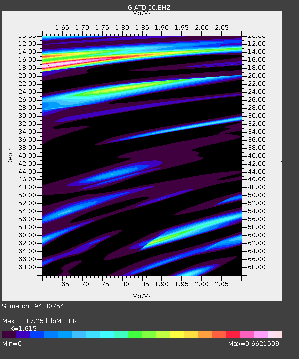
| Estimated Moho Depth: |
17.25 km |
| Estimated Crust Vp/Vs: |
1.62 |
| Assumed Crust Vp: |
6.375 km/s |
| Estimated Crust Vs: |
3.947 km/s |
| Estimated Crust Poisson's Ratio: |
0.19 |
|
| Radial Match: |
94.30754 % |
| Radial Bump: |
325 |
| Transverse Match: |
78.55961 % |
| Transverse Bump: |
400 |
| SOD ConfigId: |
1259291 |
| Insert Time: |
2015-12-21 08:42:31.485 +0000 |
| GWidth: |
2.5 |
| Max Bumps: |
400 |
| Tol: |
0.001 |
|
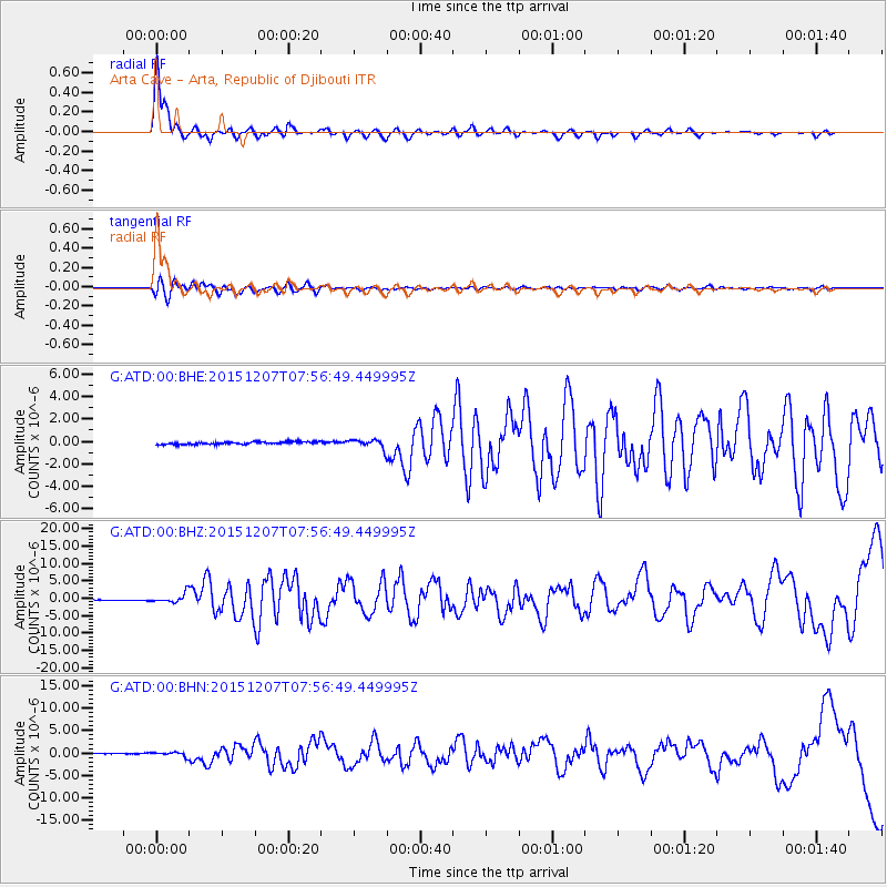
Signal To Noise
| Channel | StoN | STA | LTA |
| G:ATD:00:BHZ:20151207T07:56:49.449995Z | 9.188404 | 1.3011459E-6 | 1.4160739E-7 |
| G:ATD:00:BHN:20151207T07:56:49.449995Z | 4.0059695 | 4.63501E-7 | 1.15702576E-7 |
| G:ATD:00:BHE:20151207T07:56:49.449995Z | 3.256132 | 3.743709E-7 | 1.1497412E-7 |
| Arrivals |
| Ps | 1.8 SECOND |
| PpPs | 6.5 SECOND |
| PsPs/PpSs | 8.3 SECOND |


