You are here: Home > Network List > AV - Alaska Volcano Observatory Stations List
> Station MAPS Pakushin Southeast, Makushin Volcano, Alaska > Earthquake Result Viewer
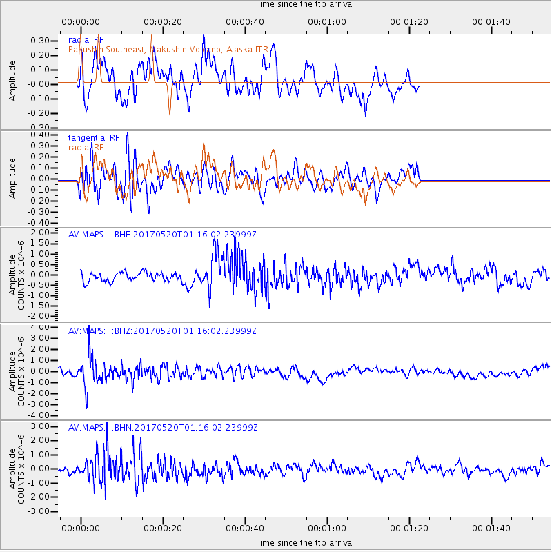
MAPS Pakushin Southeast, Makushin Volcano, Alaska - Earthquake Result Viewer
*The percent match for this event was below the threshold and hence no stack was calculated.
| Earthquake location: |
Negros, Philippines |
| Earthquake latitude/longitude: |
9.4/124.0 |
| Earthquake time(UTC): |
2017/05/20 (140) 01:06:13 GMT |
| Earthquake Depth: |
521 km |
| Earthquake Magnitude: |
5.9 Mww |
| Earthquake Catalog/Contributor: |
NEIC PDE/us |
|
| Network: |
AV Alaska Volcano Observatory |
| Station: |
MAPS Pakushin Southeast, Makushin Volcano, Alaska |
| Lat/Lon: |
53.81 N/166.94 W |
| Elevation: |
333 m |
|
| Distance: |
70.2 deg |
| Az: |
36.083 deg |
| Baz: |
258.499 deg |
| Ray Param: |
$rayparam |
*The percent match for this event was below the threshold and hence was not used in the summary stack. |
|
| Radial Match: |
41.75913 % |
| Radial Bump: |
400 |
| Transverse Match: |
55.25846 % |
| Transverse Bump: |
400 |
| SOD ConfigId: |
13570011 |
| Insert Time: |
2019-04-28 01:27:09.582 +0000 |
| GWidth: |
2.5 |
| Max Bumps: |
400 |
| Tol: |
0.001 |
|
Signal To Noise
| Channel | StoN | STA | LTA |
| AV:MAPS: :BHZ:20170520T01:16:02.23999Z | 6.0329094 | 1.4079909E-6 | 2.3338505E-7 |
| AV:MAPS: :BHN:20170520T01:16:02.23999Z | 2.399295 | 7.387284E-7 | 3.078939E-7 |
| AV:MAPS: :BHE:20170520T01:16:02.23999Z | 4.4292727 | 8.952992E-7 | 2.0213231E-7 |
| Arrivals |
| Ps | |
| PpPs | |
| PsPs/PpSs | |


