You are here: Home > Network List > CI - Caltech Regional Seismic Network Stations List
> Station MWC Mount Wilson Obsv, Altadena, CA, USA > Earthquake Result Viewer
MWC Mount Wilson Obsv, Altadena, CA, USA - Earthquake Result Viewer
| Earthquake location: |
Near West Coast Of Colombia |
| Earthquake latitude/longitude: |
3.0/-78.0 |
| Earthquake time(UTC): |
2007/09/10 (253) 01:49:14 GMT |
| Earthquake Depth: |
31 km |
| Earthquake Magnitude: |
6.1 MB, 6.7 MS, 6.8 MW |
| Earthquake Catalog/Contributor: |
WHDF/NEIC |
|
| Network: |
CI Caltech Regional Seismic Network |
| Station: |
MWC Mount Wilson Obsv, Altadena, CA, USA |
| Lat/Lon: |
34.22 N/118.06 W |
| Elevation: |
1725 m |
|
| Distance: |
48.5 deg |
| Az: |
314.606 deg |
| Baz: |
120.899 deg |
| Ray Param: |
0.06922779 |
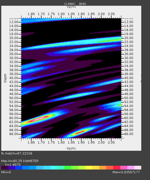
| Estimated Moho Depth: |
60.25 km |
| Estimated Crust Vp/Vs: |
1.69 |
| Assumed Crust Vp: |
6.1 km/s |
| Estimated Crust Vs: |
3.615 km/s |
| Estimated Crust Poisson's Ratio: |
0.23 |
|
| Radial Match: |
97.32336 % |
| Radial Bump: |
352 |
| Transverse Match: |
90.30355 % |
| Transverse Bump: |
400 |
| SOD ConfigId: |
2564 |
| Insert Time: |
2010-02-26 01:12:03.843 +0000 |
| GWidth: |
2.5 |
| Max Bumps: |
400 |
| Tol: |
0.001 |
|

Signal To Noise
| Channel | StoN | STA | LTA |
| CI:MWC: :BHN:20070910T01:57:23.834014Z | 1.636523 | 5.6520963E-7 | 3.4537223E-7 |
| CI:MWC: :BHE:20070910T01:57:23.834014Z | 3.1802523 | 7.0764077E-7 | 2.2251089E-7 |
| CI:MWC: :BHZ:20070910T01:57:23.834014Z | 7.187888 | 1.3723029E-6 | 1.909188E-7 |
| Arrivals |
| Ps | 7.2 SECOND |
| PpPs | 25 SECOND |
| PsPs/PpSs | 32 SECOND |


