You are here: Home > Network List > IU - Global Seismograph Network (GSN - IRIS/USGS) Stations List
> Station KMBO Kilima Mbogo, Kenya > Earthquake Result Viewer
KMBO Kilima Mbogo, Kenya - Earthquake Result Viewer
| Earthquake location: |
Tajikistan |
| Earthquake latitude/longitude: |
38.3/72.7 |
| Earthquake time(UTC): |
2015/12/07 (341) 07:50:07 GMT |
| Earthquake Depth: |
29 km |
| Earthquake Magnitude: |
7.2 MWB |
| Earthquake Catalog/Contributor: |
NEIC PDE/NEIC COMCAT |
|
| Network: |
IU Global Seismograph Network (GSN - IRIS/USGS) |
| Station: |
KMBO Kilima Mbogo, Kenya |
| Lat/Lon: |
1.13 S/37.25 E |
| Elevation: |
1950 m |
|
| Distance: |
51.0 deg |
| Az: |
228.26 deg |
| Baz: |
35.98 deg |
| Ray Param: |
0.06762367 |
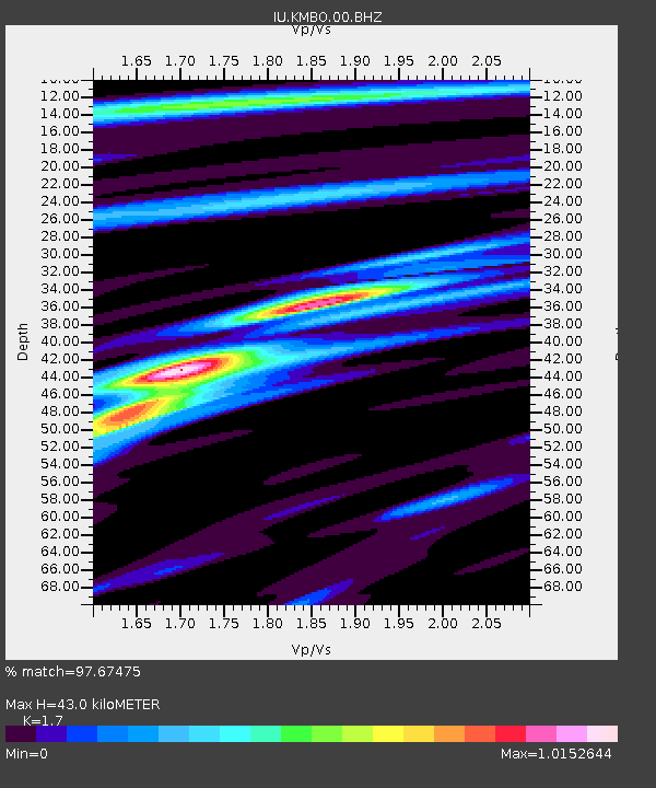
| Estimated Moho Depth: |
43.0 km |
| Estimated Crust Vp/Vs: |
1.70 |
| Assumed Crust Vp: |
6.601 km/s |
| Estimated Crust Vs: |
3.883 km/s |
| Estimated Crust Poisson's Ratio: |
0.24 |
|
| Radial Match: |
97.67475 % |
| Radial Bump: |
259 |
| Transverse Match: |
87.05925 % |
| Transverse Bump: |
400 |
| SOD ConfigId: |
1259291 |
| Insert Time: |
2015-12-21 08:43:57.739 +0000 |
| GWidth: |
2.5 |
| Max Bumps: |
400 |
| Tol: |
0.001 |
|

Signal To Noise
| Channel | StoN | STA | LTA |
| IU:KMBO:00:BHZ:20151207T07:58:36.018995Z | 14.389851 | 9.833641E-7 | 6.8337336E-8 |
| IU:KMBO:00:BH1:20151207T07:58:36.018995Z | 9.220691 | 3.6195226E-7 | 3.9254353E-8 |
| IU:KMBO:00:BH2:20151207T07:58:36.018995Z | 8.772815 | 3.2932746E-7 | 3.7539543E-8 |
| Arrivals |
| Ps | 4.9 SECOND |
| PpPs | 17 SECOND |
| PsPs/PpSs | 21 SECOND |


