You are here: Home > Network List > TA - USArray Transportable Network (new EarthScope stations) Stations List
> Station F21K Alatna River, AK, USA > Earthquake Result Viewer
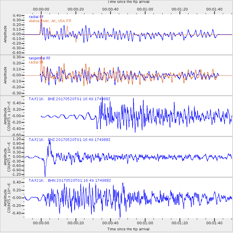
F21K Alatna River, AK, USA - Earthquake Result Viewer
*The percent match for this event was below the threshold and hence no stack was calculated.
| Earthquake location: |
Negros, Philippines |
| Earthquake latitude/longitude: |
9.4/124.0 |
| Earthquake time(UTC): |
2017/05/20 (140) 01:06:13 GMT |
| Earthquake Depth: |
521 km |
| Earthquake Magnitude: |
5.9 Mww |
| Earthquake Catalog/Contributor: |
NEIC PDE/us |
|
| Network: |
TA USArray Transportable Network (new EarthScope stations) |
| Station: |
F21K Alatna River, AK, USA |
| Lat/Lon: |
67.22 N/153.48 W |
| Elevation: |
597 m |
|
| Distance: |
78.5 deg |
| Az: |
23.202 deg |
| Baz: |
266.787 deg |
| Ray Param: |
$rayparam |
*The percent match for this event was below the threshold and hence was not used in the summary stack. |
|
| Radial Match: |
67.3884 % |
| Radial Bump: |
400 |
| Transverse Match: |
60.996727 % |
| Transverse Bump: |
400 |
| SOD ConfigId: |
13570011 |
| Insert Time: |
2019-04-28 01:29:38.383 +0000 |
| GWidth: |
2.5 |
| Max Bumps: |
400 |
| Tol: |
0.001 |
|
Signal To Noise
| Channel | StoN | STA | LTA |
| TA:F21K: :BHZ:20170520T01:16:49.174988Z | 12.208658 | 5.229594E-7 | 4.2835126E-8 |
| TA:F21K: :BHN:20170520T01:16:49.174988Z | 1.8500609 | 8.6007375E-8 | 4.6488942E-8 |
| TA:F21K: :BHE:20170520T01:16:49.174988Z | 5.3108506 | 1.824167E-7 | 3.4347924E-8 |
| Arrivals |
| Ps | |
| PpPs | |
| PsPs/PpSs | |


