You are here: Home > Network List > TA - USArray Transportable Network (new EarthScope stations) Stations List
> Station H23K Yukon River, AK, USA > Earthquake Result Viewer
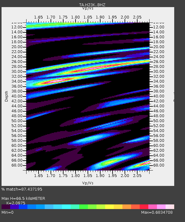
H23K Yukon River, AK, USA - Earthquake Result Viewer
| Earthquake location: |
Negros, Philippines |
| Earthquake latitude/longitude: |
9.4/124.0 |
| Earthquake time(UTC): |
2017/05/20 (140) 01:06:13 GMT |
| Earthquake Depth: |
521 km |
| Earthquake Magnitude: |
5.9 Mww |
| Earthquake Catalog/Contributor: |
NEIC PDE/us |
|
| Network: |
TA USArray Transportable Network (new EarthScope stations) |
| Station: |
H23K Yukon River, AK, USA |
| Lat/Lon: |
65.83 N/149.54 W |
| Elevation: |
617 m |
|
| Distance: |
80.1 deg |
| Az: |
24.665 deg |
| Baz: |
270.669 deg |
| Ray Param: |
0.046986353 |
| Estimated Moho Depth: |
66.5 km |
| Estimated Crust Vp/Vs: |
2.10 |
| Assumed Crust Vp: |
6.566 km/s |
| Estimated Crust Vs: |
3.13 km/s |
| Estimated Crust Poisson's Ratio: |
0.35 |
|
| Radial Match: |
87.437195 % |
| Radial Bump: |
400 |
| Transverse Match: |
84.98417 % |
| Transverse Bump: |
400 |
| SOD ConfigId: |
13570011 |
| Insert Time: |
2019-04-28 01:29:49.945 +0000 |
| GWidth: |
2.5 |
| Max Bumps: |
400 |
| Tol: |
0.001 |
|

Signal To Noise
| Channel | StoN | STA | LTA |
| TA:H23K: :BHZ:20170520T01:16:57.325012Z | 22.696735 | 1.1047417E-6 | 4.8674035E-8 |
| TA:H23K: :BHN:20170520T01:16:57.325012Z | 3.874804 | 1.8490671E-7 | 4.7720274E-8 |
| TA:H23K: :BHE:20170520T01:16:57.325012Z | 6.6140823 | 3.0922604E-7 | 4.6752675E-8 |
| Arrivals |
| Ps | 11 SECOND |
| PpPs | 31 SECOND |
| PsPs/PpSs | 42 SECOND |


