You are here: Home > Network List > TA - USArray Transportable Network (new EarthScope stations) Stations List
> Station I27K Kandik River, AK, USA > Earthquake Result Viewer
I27K Kandik River, AK, USA - Earthquake Result Viewer
| Earthquake location: |
Negros, Philippines |
| Earthquake latitude/longitude: |
9.4/124.0 |
| Earthquake time(UTC): |
2017/05/20 (140) 01:06:13 GMT |
| Earthquake Depth: |
521 km |
| Earthquake Magnitude: |
5.9 Mww |
| Earthquake Catalog/Contributor: |
NEIC PDE/us |
|
| Network: |
TA USArray Transportable Network (new EarthScope stations) |
| Station: |
I27K Kandik River, AK, USA |
| Lat/Lon: |
65.60 N/141.62 W |
| Elevation: |
874 m |
|
| Distance: |
83.3 deg |
| Az: |
24.642 deg |
| Baz: |
277.886 deg |
| Ray Param: |
0.04475524 |
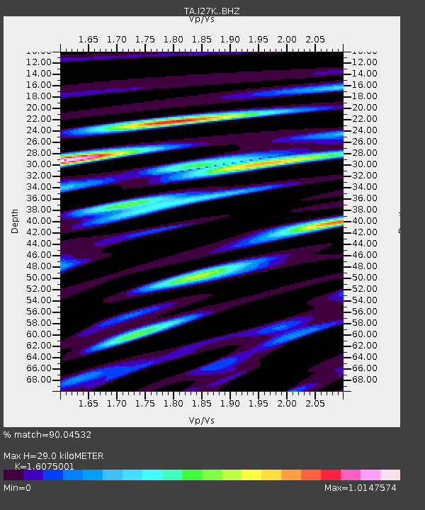
| Estimated Moho Depth: |
29.0 km |
| Estimated Crust Vp/Vs: |
1.61 |
| Assumed Crust Vp: |
6.566 km/s |
| Estimated Crust Vs: |
4.085 km/s |
| Estimated Crust Poisson's Ratio: |
0.18 |
|
| Radial Match: |
90.04532 % |
| Radial Bump: |
400 |
| Transverse Match: |
87.182045 % |
| Transverse Bump: |
400 |
| SOD ConfigId: |
13570011 |
| Insert Time: |
2019-04-28 01:29:56.178 +0000 |
| GWidth: |
2.5 |
| Max Bumps: |
400 |
| Tol: |
0.001 |
|

Signal To Noise
| Channel | StoN | STA | LTA |
| TA:I27K: :BHZ:20170520T01:17:14.000Z | 43.227737 | 2.3721145E-6 | 5.487483E-8 |
| TA:I27K: :BHN:20170520T01:17:14.000Z | 6.062749 | 4.5154397E-7 | 7.447842E-8 |
| TA:I27K: :BHE:20170520T01:17:14.000Z | 15.965133 | 7.9326406E-7 | 4.9687284E-8 |
| Arrivals |
| Ps | 2.8 SECOND |
| PpPs | 11 SECOND |
| PsPs/PpSs | 14 SECOND |


